IMAGES TAKEN NEAR TO
Glenfield Avenue, PAISLEY, PA2 8JH
Introduction
This page details the photographs taken nearby to Glenfield Avenue, PA2 8JH by members of the Geograph project.
The Geograph project started in 2005 with the aim of publishing, organising and preserving representative images for every square kilometre of Great Britain, Ireland and the Isle of Man.

There are currently over 7.5m images from over14,400 individuals and you can help contribute to the project by visiting https://www.geograph.org.uk
Image Map
Images are licensed for reuse under creativecommons.org/licenses/by-sa/2.0
Notes
- Clicking on the map will re-center to the selected point.
- The higher the marker number, the further away the image location is from the centre of the postcode.
Image Listing (47 Images Found)
Images are licensed for reuse under creativecommons.org/licenses/by-sa/2.0
Image
Details
Distance
1
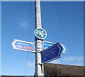
Signpost, Glenfield Road
Cyclepath signpost.
Image: © Richard Webb
Taken: 6 Nov 2016
0.07 miles
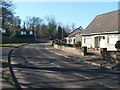
2
Glenburn Road
To the left is woodland on former industrial land.
Image: © Richard Webb
Taken: 6 Nov 2016
0.07 miles
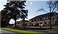
3
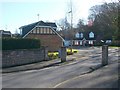
Glen Lodge Visitor Centre
Glen Lodge is located at one of the access points to Gleniffer Braes Country Park, and provides a base for the park's Land Services team. The path shown in this photograph provides access to the park from Image, which is visible just beyond the lodge.
On the near side of the visitor centre is an information panel, which includes a map of the park. It is noted there that "Gleniffer Braes Country Park lies to the south of the town of Paisley. With approximately 1300 acres, it is just over three miles long and one mile wide."
Image: © Lairich Rig
Taken: 28 Feb 2011
0.08 miles
5
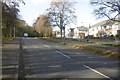
Glenfield Road
The same road is shown in Image, curving to the right. The present photograph shows the part of the road that is just around the corner.
The buildings to the left of the road are in Image; the entrance from which that picture was taken can be seen near the centre of the present photograph. Also on the left-hand side of Glenfield Road, but located about 75 metres past the entrance to Glenfield Grange, is the start of a path that leads into Gleniffer Braes Country Park: Image
Image: © Lairich Rig
Taken: 28 Feb 2011
0.09 miles
6
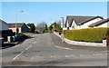
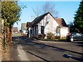
Glenfield Avenue
The photograph was taken from the junction with Glenfield Road; that road appears in the foreground (see Image, which also shows the junction from which the present picture was taken).
Not far ahead, on the left, is the junction with Glenfield Crescent.
Image: © Lairich Rig
Taken: 28 Feb 2011
0.09 miles
7
Speed camera on Glenburn Road Paisley
Pictured 30th July 2009 7.55p.m.
Image: © Gordon Dowie
Taken: 30 Jul 2009
0.10 miles
8

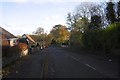
Glenfield Road
This is the same road as shown in Image, but the present photograph is a view in the opposite direction; in addition, it was taken from a point about 20 metres further to the SSW, so as to cross an intervening OS grid line.
Not far ahead on the right is the junction with Image (from the pavement opposite that junction, I took a picture of Image). Further ahead, Glenfield Road curves out of sight, to the right; for a view around that corner, see Image
Image: © Lairich Rig
Taken: 28 Feb 2011
0.12 miles
9
Glenfield Grange
The photograph was taken from the point where Glenfield Grange branches off from Image; the junction can be seen in that linked photograph.
Image: © Lairich Rig
Taken: 28 Feb 2011
0.12 miles
10
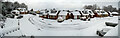
Glenfield Grange in the sow
Panorama created 24/02/2022
Image: © Robert Purdie
Taken: 24 Feb 2022
0.12 miles