IMAGES TAKEN NEAR TO
Cumbrae Road, PAISLEY, PA2 8HA
Introduction
This page details the photographs taken nearby to Cumbrae Road, PA2 8HA by members of the Geograph project.
The Geograph project started in 2005 with the aim of publishing, organising and preserving representative images for every square kilometre of Great Britain, Ireland and the Isle of Man.

There are currently over 7.5m images from over14,400 individuals and you can help contribute to the project by visiting https://www.geograph.org.uk
Image Map
Images are licensed for reuse under creativecommons.org/licenses/by-sa/2.0
Notes
- Clicking on the map will re-center to the selected point.
- The higher the marker number, the further away the image location is from the centre of the postcode.
Image Listing (28 Images Found)
Images are licensed for reuse under creativecommons.org/licenses/by-sa/2.0
Image
Details
Distance
2
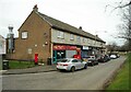
Shops, Sanda Way
The large chimney belongs to iEat, a Chinese takeaway.
Image: © Richard Sutcliffe
Taken: 23 Feb 2023
0.05 miles
3
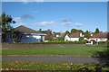
Glenburn Road
The through road version of Glenburn Road on the left is separated from the residnetial Glenburn Road on the right by a grassy strip with trees.
Image: © Richard Sutcliffe
Taken: 23 Feb 2023
0.07 miles
4
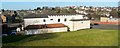
Gleniffer Hotel
The photograph was taken from beside Caplethill Road. Parallel to that, and visible here running from left to right behind the hotel, is Glenburn Road.
Fairway Avenue can be seen receding behind the left-hand edge of the building. For a view of the hotel from a different angle, see Image As for its name, Gleniffer Braes Country Park is located not far to the SSW (the Gleniffer Burn flows through part of the park in Image).
Image: © Lairich Rig
Taken: 28 Feb 2011
0.08 miles
5
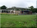
Glennifer Hotel
On Glenburn Road, Paisley.
Image: © Stephen Sweeney
Taken: 12 Aug 2009
0.08 miles
6
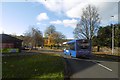
Glenburn Road, Paisley
A McGills bus running up from the city centre.
Image: © Richard Webb
Taken: 6 Nov 2016
0.10 miles
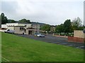
7
Disused petrol station
At the junction of Caplethill Road and Glenburn Road.
Image: © Stephen Sweeney
Taken: 12 Aug 2009
0.11 miles
8

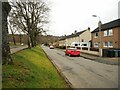
Caplethill Road, Paisley
Brownside Braes can be seen in the background.
Image: © Thomas Nugent
Taken: 18 May 2006
0.12 miles
9
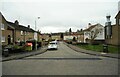
Southfield Avenue
The photograph was taken from the junction with Caplethill Road (which, about 200 metres to the NNE, becomes Neilston Road).
Image: © Lairich Rig
Taken: 28 Feb 2011
0.12 miles