IMAGES TAKEN NEAR TO
Pentland Crescent, PAISLEY, PA2 8BS
Introduction
This page details the photographs taken nearby to Pentland Crescent, PA2 8BS by members of the Geograph project.
The Geograph project started in 2005 with the aim of publishing, organising and preserving representative images for every square kilometre of Great Britain, Ireland and the Isle of Man.

There are currently over 7.5m images from over14,400 individuals and you can help contribute to the project by visiting https://www.geograph.org.uk
Image Map
Images are licensed for reuse under creativecommons.org/licenses/by-sa/2.0
Notes
- Clicking on the map will re-center to the selected point.
- The higher the marker number, the further away the image location is from the centre of the postcode.
Image Listing (4 Images Found)
Images are licensed for reuse under creativecommons.org/licenses/by-sa/2.0
Image
Details
Distance
1
Glenburn Health Centre and Glenburn Library
On Fairway Avenue, Glenburn, Paisley.
Image: © G Laird
Taken: 25 Apr 2014
0.17 miles
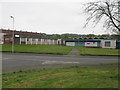
2

Former railway station
Located off Neilston Road, Paisley, this was originally Potterhill station on the long since closed Paisley-Barrhead line.
Image: © Thomas Nugent
Taken: 18 May 2006
0.21 miles
3
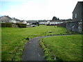
Green space behind houses
Amenity grassland behind Fairway Avenue (on the left) and Denewood Avenue (in the distance).
Image: © Richard Sutcliffe
Taken: 14 Apr 2023
0.22 miles
4
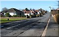
Southfield Avenue
The photograph was taken from the junction with Caplethill Road (which, about 200 metres to the NNE, becomes Neilston Road).
Image: © Lairich Rig
Taken: 28 Feb 2011
0.24 miles