IMAGES TAKEN NEAR TO
March Brae, CAIRNDOW, PA27 8BA
Introduction
This page details the photographs taken nearby to March Brae, PA27 8BA by members of the Geograph project.
The Geograph project started in 2005 with the aim of publishing, organising and preserving representative images for every square kilometre of Great Britain, Ireland and the Isle of Man.

There are currently over 7.5m images from over14,400 individuals and you can help contribute to the project by visiting https://www.geograph.org.uk
Image Map (Loading...)


Getting Data...Please wait
Leaflet Map data © OpenStreetMap
Images are licensed for reuse under creativecommons.org/licenses/by-sa/2.0
Notes
- Clicking on the map will re-center to the selected point.
- The higher the marker number, the further away the image location is from the centre of the postcode.
Image Listing (11 Images Found)
Images are licensed for reuse under creativecommons.org/licenses/by-sa/2.0
Image
Details
Distance
1
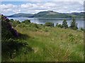
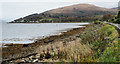
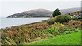
Grassy slopes above Strachur
Looking over Loch Fyne. Lots of Rhododendrons hereabouts.
Image: © Roger McLachlan
Taken: 13 Jun 2008
0.06 miles
4
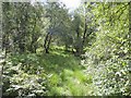
Mixed woodland above Strachur
Pleasant walking through this woodland, a lot of beech further up the hill.
Image: © Roger McLachlan
Taken: 13 Jun 2008
0.10 miles
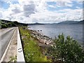
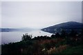
5
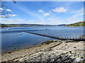
Shore at Strachur
The names Strachur, Clachan and Strachur Clachan occur variously on OS maps in this area on the east side of Loch Fyne, generally though it seems that the settlement is known as Strachur. The shore is part of Strachur Bay or leads to it.
The hill in the distance is Creagan an Eich.
Image: © Trevor Littlewood
Taken: 22 Oct 2019
0.10 miles
7
Loch Fyne, Shoreline at Clach Dhubh na Criche
Image: © william craig
Taken: 27 Jun 2006
0.16 miles
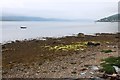
9
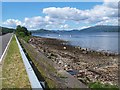
Shore of Loch Fyne near to Creag nam Faoileann
The loch shore is towards the south-western end of the ribbon of development alongside the A886 at Strachur, the image itself having been recorded from beside a cross named on OS maps at the 1:50 000 & 1:25 000 scales simply as a monument, but at larger scales as a war memorial. The cross is indeed a memorial to two soldiers who died in battle, a captain and a private; they died in separate years in South African wars but it's not a war memorial in the usually understood sense which would be to the dead of both or one of the two World Wars.
Image: © Trevor Littlewood
Taken: 22 Oct 2019
0.19 miles
10
Loch Fyne from behind the War Memorial
Image: © Elliott Simpson
Taken: Unknown
0.21 miles