IMAGES TAKEN NEAR TO
Sandbank, DUNOON, PA23 8QD
Introduction
This page details the photographs taken nearby to PA23 8QD by members of the Geograph project.
The Geograph project started in 2005 with the aim of publishing, organising and preserving representative images for every square kilometre of Great Britain, Ireland and the Isle of Man.

There are currently over 7.5m images from over14,400 individuals and you can help contribute to the project by visiting https://www.geograph.org.uk
Image Map
Images are licensed for reuse under creativecommons.org/licenses/by-sa/2.0
Notes
- Clicking on the map will re-center to the selected point.
- The higher the marker number, the further away the image location is from the centre of the postcode.
Image Listing (42 Images Found)
Images are licensed for reuse under creativecommons.org/licenses/by-sa/2.0
Image
Details
Distance
1
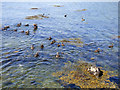
Ducks in the Holy Loch
Fleeing from the curious photographer who dared look over the wall at the A815 road near Fir Brae.
Image: © Thomas Nugent
Taken: 2 Jul 2018
0.07 miles
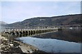
2
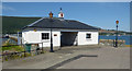
Ardnadam Pier
The ticket office by the A815 Shore Road. The pier was opened in 1858 to serve a growing development of marine villas to the north-west of Sandbank and is the longest steamer pier on the upper firth of Clyde. The pier was used by steamer services in the heyday of the Clyde steamers before the First World War, but was closed to commercial use in 1940 and never reopened. It was used for military purposes when the US Navy base at Holy Loch was in operation (1961-1992).
Image: © Thomas Nugent
Taken: 2 Jul 2018
0.08 miles
3
Ardnadam Pier
Image: © Thomas Nugent
Taken: 1 Jul 2019
0.08 miles
4
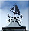
Ardnadam Pier weather vane
Image: © Thomas Nugent
Taken: 1 Jul 2019
0.08 miles
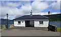
5

Ardnadam Pier Ticket Office
The pier is having work done, but the office looks as if it has been recently repainted. See John M's description Image for a history of the 160 year-old pier.
Image: © M J Richardson
Taken: 30 May 2017
0.08 miles
6
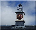
Ardnadam Pier clock
Image: © Thomas Nugent
Taken: 1 Jul 2019
0.08 miles
7

Ardnadam Pier
The ticket office by the A815 Shore Road. The pier was opened in 1858 to serve a growing development of marine villas to the north-west of Sandbank and is the longest steamer pier on the upper firth of Clyde. The pier was used by steamer services in the heyday of the Clyde steamers before the First World War, but was closed to commercial use in 1940 and never reopened. It was used for military purposes when the US Navy base at Holy Loch was in operation (1961-1992).
Image: © Thomas Nugent
Taken: 2 Jul 2018
0.09 miles
8
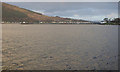
Ardnadam Pier
Viewed from the swing park at Sandbank. Compare with the same scene in July 2019 Image
Image: © Thomas Nugent
Taken: 30 Dec 2019
0.10 miles
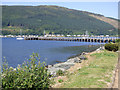
9
Ardnadam Pier
In the Holy Loch, dates to the 1850s.
Image: © Richard Webb
Taken: 26 Mar 2017
0.11 miles
10
Ardnadam Pier
On the south shore of the Holy Loch. The pier was opened in 1858 to serve a growing development of marine villas to the north-west of Sandbank and is the longest steamer pier on the upper firth of Clyde. The pier was used by steamer services in the heyday of the Clyde steamers before the First World War, but was closed to commercial use in 1940 and never reopened. It was used for military purposes when the US Navy base at Holy Loch was in operation (1961-1992).
Image: © Thomas Nugent
Taken: 2 Jul 2018
0.11 miles