IMAGES TAKEN NEAR TO
Durrockstock Road, PAISLEY, PA2 0AL
Introduction
This page details the photographs taken nearby to Durrockstock Road, PA2 0AL by members of the Geograph project.
The Geograph project started in 2005 with the aim of publishing, organising and preserving representative images for every square kilometre of Great Britain, Ireland and the Isle of Man.

There are currently over 7.5m images from over14,400 individuals and you can help contribute to the project by visiting https://www.geograph.org.uk
Image Map
Images are licensed for reuse under creativecommons.org/licenses/by-sa/2.0
Notes
- Clicking on the map will re-center to the selected point.
- The higher the marker number, the further away the image location is from the centre of the postcode.
Image Listing (13 Images Found)
Images are licensed for reuse under creativecommons.org/licenses/by-sa/2.0
Image
Details
Distance
2
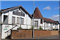
Foxbar Road
Not far ahead, on the left, is the turning for Amochrie Road. The two high flats in the distance are (l-r) Gleniffer Court and Nethercraigs Court, and they are shown in Image
Image: © Lairich Rig
Taken: 28 Feb 2011
0.08 miles
3
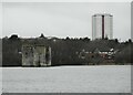
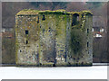
Ancient and modern
The early 15th century Stanely Castle https://canmore.org.uk/site/43150/paisley-stanely-castle, now surrounded by Stanely Reservoir and the late 1950s Oliphant Court. The tower block is the only one remaining of five tower blocks built between 1958 and 1960, designed by John Alexander McGregor, Paisley Burgh Engineer's Department.
Image: © Richard Sutcliffe
Taken: 23 Feb 2023
0.14 miles
4
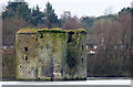
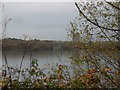
Stanely Castle
For earlier pictures, see Image / Image / Image; see the first of those links, in particular, for more info.
As the map shows, the castle is not on the shore, but, for reasons that are explained in the end-note, out in the water. It is thought to date from the early fifteenth century, and it originally stood on an island in a marsh; the current setting is similar except in degree.
The New Statistical Account's description of Paisley says that the height is "about forty feet, fully ten feet lower than the most elevated part of Cruikston Castle" (Image).
It goes on to cite Crawford's "History of the Shire of Renfrew" to show that the "castle and barony of Stainly" were "anciently a possession of the Denelstouns of that ilk" (Danzielston/Danȝielstone — see my discussion at Image), later passing into the hands of the Maxwells of Calderwood, and, still later, the Earl of Glasgow. For more about that, see the link mentioned in the first paragraph.
Image: © Lairich Rig
Taken: 31 May 2017
0.18 miles
5
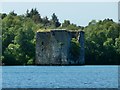
Stanely Reservoir and Castle
The ruined early 15th Century castle is at the west end of the reservoir and is surrounded by water which covers the ground floor.
Image: © Thomas Nugent
Taken: 29 Feb 2016
0.18 miles
6
Stanely Reservoir and Castle
The ruined early 15th Century castle is at the west end of the reservoir and is surrounded by water which covers the ground floor.
Image: © Thomas Nugent
Taken: 29 Feb 2016
0.18 miles
7
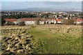
Grassy area above the Hollows
This area, bounded on the south by Gleniffer Road, and on the north by housing, lies within the much larger Gleniffer Braes Country Park.
Visible not far ahead, down the slope, are the backs of houses in the Hollows, a part of Foxbar; those houses are on Hollows Avenue.
Image: © Lairich Rig
Taken: 28 Feb 2011
0.19 miles
8
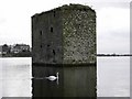
Stanely Castle
Stanely Castle
*************
I have around 50 pictures of the castle in my collection.
Built in the early 15th century, Stanely Castle, to the west of Paisley, is still standing today, despite sitting in the middle of a reservoir.
More information - https://www.britainirelandcastles.com/Scotland/Renfrewshire/Stanely-Castle.html
Image: © Vic Nelson
Taken: 5 Mar 2007
0.19 miles
9
Stanely Castle
From across the reservoir by Stanely Cottage.
Image: © Stephen Sweeney
Taken: 29 Oct 2009
0.19 miles
10
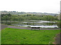
Durrockstock Dam, Foxbar, Paisley
Pond in Durrockstock Park just to the east of Waverley Road.
Image: © G Laird
Taken: 28 Apr 2014
0.24 miles