IMAGES TAKEN NEAR TO
Ascog, ISLE OF BUTE, PA20 9LN
Introduction
This page details the photographs taken nearby to PA20 9LN by members of the Geograph project.
The Geograph project started in 2005 with the aim of publishing, organising and preserving representative images for every square kilometre of Great Britain, Ireland and the Isle of Man.

There are currently over 7.5m images from over14,400 individuals and you can help contribute to the project by visiting https://www.geograph.org.uk
Image Map
Images are licensed for reuse under creativecommons.org/licenses/by-sa/2.0
Notes
- Clicking on the map will re-center to the selected point.
- The higher the marker number, the further away the image location is from the centre of the postcode.
Image Listing (15 Images Found)
Images are licensed for reuse under creativecommons.org/licenses/by-sa/2.0
Image
Details
Distance
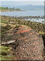
2
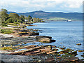
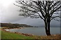
The Shore at Ascog
Distinctively eroded outcrops of Old Red Sandstone line the shore at Ascog. In the background is the Cowal peninsula, and the Caledonian MacBrayne ferry on its way from Rothesay to Wemyss Bay.
Image: © Anne Burgess
Taken: 18 Sep 2011
0.04 miles

4
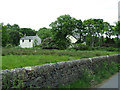
Red sandstone bedrock
Looking towards Ascog from near Ascog Bridge, Ascog Church tower is visible in the distance.
Image: © Thomas Nugent
Taken: 13 Jun 2013
0.10 miles
5
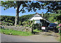
Cottage at Hawkstone
Unusual design, without windows on the ground floor on this side.
Image: © Thomas Nugent
Taken: 13 Jun 2013
0.11 miles
6
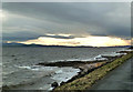
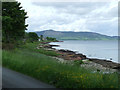
Firth of Clyde View
A cloudy late-January morning view of the Firth of Clyde looking from the Bute shore where the A844 uses the post-glacial raised beach.
Image: © Mary and Angus Hogg
Taken: 29 Jan 2014
0.11 miles
8
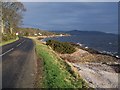
Shoreline south of Ascog
Outcrops of old red sandstone along the shore here denote that we are in the Lowlands, geologically speaking. The Highland Boundary Fault is a few miles further north and runs across the island from the middle of Rothesay to Scalpsie Bay on the west coast.
Image: © Gordon Hatton
Taken: 8 May 2022
0.13 miles
9
Bute, Shoreline
Looking north near Ascog Bridge
Image: © william craig
Taken: 26 Jan 2006
0.15 miles
10
Seashore rocks
A large boulder on the shore with patches of smooth old red sandstone, and with large areas of the Bute Conglomerate [the knobbly stuff] of Devonian age.
Image: © Gordon Hatton
Taken: 8 May 2022
0.16 miles