IMAGES TAKEN NEAR TO
Wellpark Road, ISLE OF BUTE, PA20 9JY
Introduction
This page details the photographs taken nearby to Wellpark Road, PA20 9JY by members of the Geograph project.
The Geograph project started in 2005 with the aim of publishing, organising and preserving representative images for every square kilometre of Great Britain, Ireland and the Isle of Man.

There are currently over 7.5m images from over14,400 individuals and you can help contribute to the project by visiting https://www.geograph.org.uk
Image Map
Images are licensed for reuse under creativecommons.org/licenses/by-sa/2.0
Notes
- Clicking on the map will re-center to the selected point.
- The higher the marker number, the further away the image location is from the centre of the postcode.
Image Listing (44 Images Found)
Images are licensed for reuse under creativecommons.org/licenses/by-sa/2.0
Image
Details
Distance
1
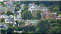
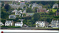
Eastlands Road, Rothesay
A steep hill which leads to Canada Hill and the top of the Serpentine Brae. Viewed from a ferry approaching Rothesay.
Image: © Thomas Nugent
Taken: 22 Aug 2024
0.03 miles
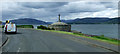
2
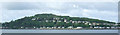
Bogany Point and Common Hill
Viewed from the ferry from Wemyss Bay to Rothesay.
Image: © Thomas Nugent
Taken: 13 Jun 2013
0.05 miles
4
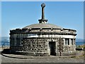
Sewage screening chamber on the sea front
Another contributor has described this as disused toilets, and it would appear that the building has a dual function, both as public conveniences and as a sewage screening chamber. Outside, pipes run out into the sea, so hopefully the effluent would be clean by the time it hit the water.
Image: © Gordon Hatton
Taken: 8 May 2022
0.05 miles
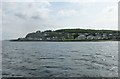
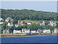
5
Rothesay from the sea
Eastlands Road, just south of Bogany Point, is prominent on the hill.
Image: © Thomas Nugent
Taken: 22 Aug 2024
0.05 miles
6
Former public toilets, Mount Stuart Road
Now disused sewage screening chamber and public toilets. A Category B Listed building http://data.historic-scotland.gov.uk/pls/htmldb/f?p=2200:15:0::::BUILDING:44886 .
Image: © Thomas Nugent
Taken: 13 Jun 2013
0.05 miles
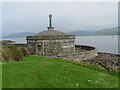
7
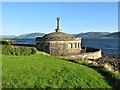
Sewage Screening Chamber and Public Convenience, Craigmore, Isle of Bute
Dating from c.1930, the sandstone circular sewage screening chamber includes male and female toilets though now disused. It is a Category B listed building. https://britishlistedbuildings.co.uk/200391608-mount-stuart-road-sewage-screening-chamber-and-public-convenience-isle-of-bute-ward#.W45quPZFw5s. This view is also looking across to the Scottish mainland.
Image: © G Laird
Taken: 3 Sep 2018
0.06 miles
8
Bogany Point
Bogany Point and Craigmore, viewed from a ferry approaching Rothesay.
Image: © Thomas Nugent
Taken: 2 Jul 2018
0.06 miles
9
Sewage Screening Chamber and Public Convenience
Former Sewage Screening Chamber and Public Convenience, Mount Stuart Road, Craigmore.
A Category B Listed Building.
Image: © Raibeart MacAoidh
Taken: 29 Jun 2018
0.06 miles
10
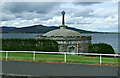
Former public toilets, Mount Stuart Road
Now disused sewage screening chamber and public toilets. A Category B Listed building http://data.historic-scotland.gov.uk/pls/htmldb/f?p=2200:15:0::::BUILDING:44886 .
Image: © Thomas Nugent
Taken: 13 Jun 2013
0.06 miles