IMAGES TAKEN NEAR TO
Glen Douglas Way, GREENOCK, PA16 9NU
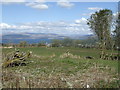
Introduction
This page details the photographs taken nearby to Glen Douglas Way, PA16 9NU by members of the Geograph project.
The Geograph project started in 2005 with the aim of publishing, organising and preserving representative images for every square kilometre of Great Britain, Ireland and the Isle of Man.

There are currently over 7.5m images from over14,400 individuals and you can help contribute to the project by visiting https://www.geograph.org.uk
Image Map
Images are licensed for reuse under creativecommons.org/licenses/by-sa/2.0
Notes
- Clicking on the map will re-center to the selected point.
- The higher the marker number, the further away the image location is from the centre of the postcode.
Image Listing (123 Images Found)
Images are licensed for reuse under creativecommons.org/licenses/by-sa/2.0
Image
Details
Distance
1
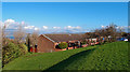
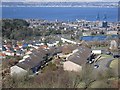
Housing, Overton, Greenock
The River Clyde and Helensburgh in the background (left).
Image: © wfmillar
Taken: 1 Nov 2011
0.05 miles
2
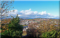
Overton, Greenock
A view over Greenock West from the car park off Glen Douglas Road, Overton.
Image: © wfmillar
Taken: 1 Nov 2011
0.06 miles
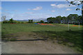
4
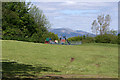
Play park at Overton
Beside the football pitch off Papermill Road.
Image: © Thomas Nugent
Taken: 2 Jun 2013
0.10 miles
5
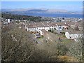
Rooftops, Glendouglas Road
Roofs of Greenock, seen from The Cut.
Image: © Richard Webb
Taken: 19 Apr 2013
0.10 miles
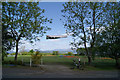
6
Football pitch at Overton
Off Papermill Road on the way to Overton from Peat Road.
Image: © Thomas Nugent
Taken: 2 Jun 2013
0.11 miles
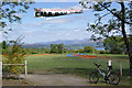
7
Football pitch at Overton
The day after Overton Gala Day.
Image: © Thomas Nugent
Taken: 2 Jun 2013
0.11 miles
8
Football pitch at Overton
The day after Overton Gala Day.
Image: © Thomas Nugent
Taken: 2 Jun 2013
0.11 miles
9
Path above Woodstock Road
Compare another picture Image; the path, though not visible in that photograph, is parallel to the road, and is at the top of the grassy bank to the right (south) of the road, between that bank and the trees.
The path and the steps that appear in the present picture now serve no useful purpose (the steps lead nowhere, and the path merely leaves and rejoins the pavement).
However, another view of the road, similar to the one linked above, but taken a few years earlier, shows buildings that used to stand here: Image The path and the steps were associated with those buildings.
Image: © Lairich Rig
Taken: 18 Aug 2014
0.11 miles
10
Football pitch at Overton
Viewed from Papermill Road. There appeared to be a community tidy-up of the area going on when this photo was taken. The River Clyde and Helensburgh are visible in the distance.
Image: © Thomas Nugent
Taken: 17 Apr 2008
0.11 miles