IMAGES TAKEN NEAR TO
Inverkip Road, GREENOCK, PA16 9AP
Introduction
This page details the photographs taken nearby to Inverkip Road, PA16 9AP by members of the Geograph project.
The Geograph project started in 2005 with the aim of publishing, organising and preserving representative images for every square kilometre of Great Britain, Ireland and the Isle of Man.

There are currently over 7.5m images from over14,400 individuals and you can help contribute to the project by visiting https://www.geograph.org.uk
Image Map
Images are licensed for reuse under creativecommons.org/licenses/by-sa/2.0
Notes
- Clicking on the map will re-center to the selected point.
- The higher the marker number, the further away the image location is from the centre of the postcode.
Image Listing (88 Images Found)
Images are licensed for reuse under creativecommons.org/licenses/by-sa/2.0
Image
Details
Distance
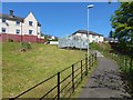
1
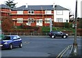
BISF renovation
British Iron & Steel Federation houses on Inverkip Road under renovation. The house on the right appears to have been bypassed. See more BISF houses in nearby Port Glasgow Image
See http://homepage.ntlworld.com/two.hd/foursteelwalls/casestudies/cs-bisf.html for more information regarding BISF houses.
Image: © Thomas Nugent
Taken: 23 Nov 2007
0.02 miles
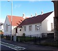
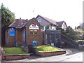
2
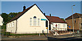
The South West Library
For earlier pictures, see Image / Image / Image Note how, in the first of those linked pictures, taken several years before the other two, the building still has very much the appearance of a private dwelling.
Image: © Lairich Rig
Taken: 16 May 2018
0.05 miles
3
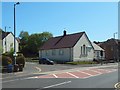
South West Library
By the A78 Inverkip Road at Barrs Cottage.
See also Image
Image: © Thomas Nugent
Taken: 10 Jul 2013
0.05 miles
4
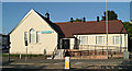
South West Library
By the A78 Inverkip Road at Barrs Cottage.
See also Image
Image: © Thomas Nugent
Taken: 10 Jul 2013
0.05 miles
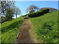
5
Path to Rankin Street
Image: © Lairich Rig
Taken: 16 May 2018
0.05 miles
7
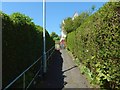
Path from Rankin Street to Rose Street
This is the second of a series of three ascending paths. Below this one is a Image, and above it is a Image
Image: © Lairich Rig
Taken: 16 May 2018
0.07 miles
8
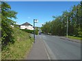
Rankin Street
The junction with Gael Street is just beyond the bus stop sign.
Image: © Lairich Rig
Taken: 16 May 2018
0.08 miles
9
Path to Buchanan Street
This path branches off from the one shown in Image, and it does so at about the point from which both this picture and that one were taken, around a third of the way up the path from Rose Street to Bow Road.
Image: © Lairich Rig
Taken: 16 May 2018
0.11 miles
10
Former Police Office at Barrs Cottage
Now a double glazing showroom.
Image: © Thomas Nugent
Taken: 5 Mar 2007
0.12 miles