IMAGES TAKEN NEAR TO
Lyle Place, GREENOCK, PA16 7QS
Introduction
This page details the photographs taken nearby to Lyle Place, PA16 7QS by members of the Geograph project.
The Geograph project started in 2005 with the aim of publishing, organising and preserving representative images for every square kilometre of Great Britain, Ireland and the Isle of Man.

There are currently over 7.5m images from over14,400 individuals and you can help contribute to the project by visiting https://www.geograph.org.uk
Image Map (Loading...)


Getting Data...Please wait
Leaflet Map data © OpenStreetMap
Images are licensed for reuse under creativecommons.org/licenses/by-sa/2.0
Notes
- Clicking on the map will re-center to the selected point.
- The higher the marker number, the further away the image location is from the centre of the postcode.
Image Listing (237 Images Found)
Images are licensed for reuse under creativecommons.org/licenses/by-sa/2.0
Image
Details
Distance
1
Train leaving Fort Matilda station
A Scotrail Class 314 train Heading west to the next station which is the terminus at Gourock. Fort matilda station is just out of sight to the right. Viewed from Lyle Hill.
Image: © Thomas Nugent
Taken: 10 May 2016
0.02 miles
2
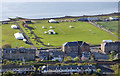
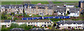
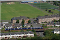
Battery Park
The marquees and barriers are in preparation for the Gourock Highland Games (the first games of the season in Scotland) which will be held the following day.
The slipway at the top left was used by flying boats during WWII, when the park was home to RAF Greenock. It was a flying boat maintenance unit, transferred away from Calshot to a more "safe" area in 1940. Much of the work performed there was equipping standard flying boats with essential RAF equipment.
Image: © Thomas Nugent
Taken: 12 May 2018
0.05 miles
3
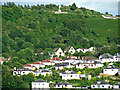
Lyle Hill
With the white anchor of the Free French war memorial Image near the horizon. Viewed from Gourock Pier.
Image: © Thomas Nugent
Taken: 29 Jun 2014
0.06 miles
4
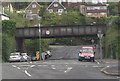
Fort Matilda railway bridge
A Class 380 train is approaching from Gourock. Battery Park is in the background. Viewed from Lyle Road.
Image: © Thomas Nugent
Taken: 8 Aug 2012
0.07 miles
5
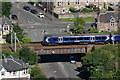
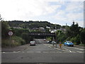
Fort Matilda railway bridge
Just west of Fort Matilda railway station. A Class 380 train is arriving from Gourock. Viewed from the top of Lyle Road.
Image: © Thomas Nugent
Taken: 8 Aug 2012
0.07 miles
6
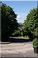
Newark Street
At the junction with Eldon Street.
Image: © Thomas Nugent
Taken: 17 Sep 2007
0.07 miles
7
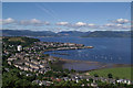
Gourock from Lyle Road
With the Holy Loch in the distance.
Image: © Thomas Nugent
Taken: 8 Aug 2012
0.07 miles
8
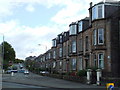
Lyle Road
A steep winding hill in the west end of Greenock. Named after former Greenock Provost Abram Lyle of the Tate & Lyle sugar firm.
Image: © Thomas Nugent
Taken: 8 Aug 2012
0.07 miles