IMAGES TAKEN NEAR TO
Fergus Place, GREENOCK, PA16 7LP
Introduction
This page details the photographs taken nearby to Fergus Place, PA16 7LP by members of the Geograph project.
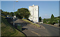
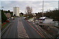
The Geograph project started in 2005 with the aim of publishing, organising and preserving representative images for every square kilometre of Great Britain, Ireland and the Isle of Man.

There are currently over 7.5m images from over14,400 individuals and you can help contribute to the project by visiting https://www.geograph.org.uk
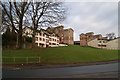
Image Map
Images are licensed for reuse under creativecommons.org/licenses/by-sa/2.0
Notes
- Clicking on the map will re-center to the selected point.
- The higher the marker number, the further away the image location is from the centre of the postcode.
Image Listing (101 Images Found)
Images are licensed for reuse under creativecommons.org/licenses/by-sa/2.0
Image
Details
Distance
1
Gleninver Road
With Neil Street in the background.
Image: © Thomas Nugent
Taken: 30 Nov 2012
0.07 miles
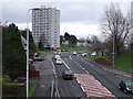
2
Gleninver Road
Sutherland Road is on the left, Ravenscraig Court is in the background.
Image: © Thomas Nugent
Taken: 10 Jul 2013
0.09 miles
3
Ravenscraig Court
Sutherland Road is in the foreground, the ambulance is on Gleninver Road.
Image: © Thomas Nugent
Taken: 10 Jul 2013
0.09 miles
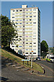
4
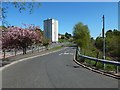
Inverkip Road
The A78 towards the centre of Greenock, viewed from the footbridge near Branchton Station. The high rise block is Ravenscraig Court.
Image: © Thomas Nugent
Taken: 23 Dec 2008
0.10 miles
5
Inverkip Road
Looking towards Ravenscraig Court from the footbridge at Branchton railway station.
Image: © Thomas Nugent
Taken: 30 Nov 2012
0.10 miles
6
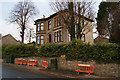
Larkfield Road
This fine big sandstone villa stands out from the council houses and flats which abound in this area.
Image: © Thomas Nugent
Taken: 30 Nov 2012
0.11 miles
7
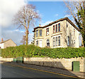
Commonhead House
On Larkfield Road, built in 1879 as the main house of an estate, now surrounded by council housing estates. More reading from this blog http://www.solsearch.us/uk-diary-page-2.htm by an ancestor of the original owner.
Image: © Thomas Nugent
Taken: 29 Jan 2017
0.11 miles
8
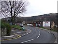
Larkfield Road
The foreground is Larkfield Road, becoming Gleninver Road towards the shop.
Image: © Thomas Nugent
Taken: 23 Dec 2008
0.11 miles
9
Branchton Road
It meets Image about 70 metres ahead; compare Image, taken near the junction. Image can be seen in the background of the present picture.
Image: © Lairich Rig
Taken: 16 May 2018
0.11 miles
10
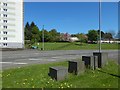
Metal blocks beside Inverkip Road
They are near the junction of Image and Image (shown crossing the image). Part of Image is in the left background.
Image: © Lairich Rig
Taken: 16 May 2018
0.12 miles