IMAGES TAKEN NEAR TO
Davey Street, GREENOCK, PA16 7JA
Introduction
This page details the photographs taken nearby to Davey Street, PA16 7JA by members of the Geograph project.
The Geograph project started in 2005 with the aim of publishing, organising and preserving representative images for every square kilometre of Great Britain, Ireland and the Isle of Man.

There are currently over 7.5m images from over14,400 individuals and you can help contribute to the project by visiting https://www.geograph.org.uk
Image Map (Loading...)


Getting Data...Please wait
Leaflet Map data © OpenStreetMap
Images are licensed for reuse under creativecommons.org/licenses/by-sa/2.0
Notes
- Clicking on the map will re-center to the selected point.
- The higher the marker number, the further away the image location is from the centre of the postcode.
Image Listing (35 Images Found)
Images are licensed for reuse under creativecommons.org/licenses/by-sa/2.0
Image
Details
Distance
1
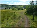
Path near Tay Street
This path is shown on large-scale OS mapping. The Clyde can be seen in the background; the far shore behind the tree that is prominent in this view is the area around Craigendoran (c.Image).
Image: © Lairich Rig
Taken: 16 Jun 2014
0.10 miles
2
Greenock Cemetery
The cemetery is built on Bow Hill. This picture was taken at one of the cemetery's high points (the summit of Bow Hill lies a little outside its boundaries).
A little beyond the rise shown in this picture is the Rankin Memorial, worth mentioning here, because it is marked on street maps of Greenock, and some readers may therefore wonder what it is: it is a Garden of Remembrance once associated with the Rankin Memorial Hospital; it occupies the northwestern extremity (the highest end) of the cemetery: Image
Image: © Lairich Rig
Taken: 8 Jul 2013
0.11 miles
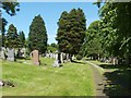
3
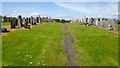
Greenock Cemetery
This is a general view of the modern part of the cemetery.
Image: © Lairich Rig
Taken: 8 Jul 2013
0.12 miles
4
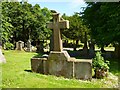
Burial place for Working Boys' Home
Inscribed on the near side: "Burial Place Belonging to Working Boys' Home".
This is point of interest № 19 on the Red Walk described in the "Greenock Cemetery Walks" booklet (see the end-note); see that reference for more on the establishment of the home.
The Working Boys' Home itself, "for destitute working lads above 14 years of age", was located at Image, formerly Banktop Cottage (or Bank Top Cottage), at the junction of Lyle Street and Bank Street.
Image: © Lairich Rig
Taken: 8 Jul 2013
0.13 miles
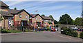
5
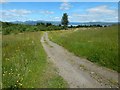
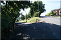
Path near Davey Street
There are several paths through this open space, some marked on large-scale mapping, others not.
Image: © Lairich Rig
Taken: 16 Jun 2014
0.13 miles
6
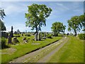
Greenock Cemetery
A difference is apparent between the areas to the left and right of the path; the more densely-wooded area on the right contains the cemetery's older memorials, while the more recent ones are located to the left.
Image: © Lairich Rig
Taken: 18 Jun 2012
0.13 miles
8
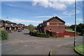
Graham Street
Off Bow Road, which is in the foreground. Greenock Cemetery is on the right.
Image: © Thomas Nugent
Taken: 8 Aug 2012
0.17 miles
9
Paton Street
At Nicol Street, off Bow Road.
Image: © Thomas Nugent
Taken: 8 Aug 2012
0.17 miles
10
Bow Road at Rose Street
Rose Street is on the left.
Image: © Thomas Nugent
Taken: 8 Aug 2012
0.17 miles