IMAGES TAKEN NEAR TO
Drumillan Hill, GREENOCK, PA16 0XE
Introduction
This page details the photographs taken nearby to Drumillan Hill, PA16 0XE by members of the Geograph project.
The Geograph project started in 2005 with the aim of publishing, organising and preserving representative images for every square kilometre of Great Britain, Ireland and the Isle of Man.

There are currently over 7.5m images from over14,400 individuals and you can help contribute to the project by visiting https://www.geograph.org.uk
Image Map
Images are licensed for reuse under creativecommons.org/licenses/by-sa/2.0
Notes
- Clicking on the map will re-center to the selected point.
- The higher the marker number, the further away the image location is from the centre of the postcode.
Image Listing (35 Images Found)
Images are licensed for reuse under creativecommons.org/licenses/by-sa/2.0
Image
Details
Distance
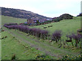
1
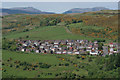
Drumillan Hill housing estate
Viewed across Spango Valley from the Greenock Cut. The track on the hill leads to Banks Farm which is obscured by trees. See my Geograph article for detail of the cut http://www.geograph.org.uk/article/The-Greenock-Cut .
Image: © Thomas Nugent
Taken: 2 Jun 2013
0.07 miles
2
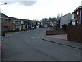
Crisswell Crescent
Part of the late 1970s Drumillan Hill housing development.
Image: © Thomas Nugent
Taken: 13 Apr 2012
0.10 miles
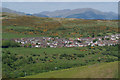
4
Earn Hill from Drumillan Hill
Viewed from the top of Drumillan Hill which is beside the housing estate of the same name.
Image: © Thomas Nugent
Taken: 13 Apr 2012
0.13 miles
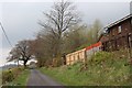
5
Track near Flatterton Farm
Leads from Flatterton Road to the fields behind Wellyard Way.
Image: © Thomas Nugent
Taken: 5 Feb 2012
0.13 miles
6
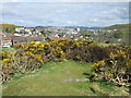
Drumillan Hill
The view towards Ravenscraig from the top of Drumillan Hill which is beside the housing estate of the same name.
Image: © Thomas Nugent
Taken: 13 Apr 2012
0.13 miles
7
Drumillan Hill housing estate
Viewed across Spango Valley from the Greenock Cut. See my Geograph article for detail of the cut http://www.geograph.org.uk/article/The-Greenock-Cut .
Image: © Thomas Nugent
Taken: 2 Jun 2013
0.15 miles
8

Spango Valley
View across the valley from Greenock Cut. Part of the IBM complex can be seen in the foreground.
Image: © Thomas Nugent
Taken: 22 Aug 2008
0.15 miles
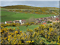
9

Leitchland Farm and Flatterton Farm
Leitchland is at the top of the hill. Viewed across Spango Valley from the Greenock Cut. The hill in the distance is across the Firth of Clyde at Dunoon.
See my geograph article for detail of the cut http://www.geograph.org.uk/article/The-Greenock-Cut .
Image: © Thomas Nugent
Taken: 2 Jun 2013
0.18 miles
10
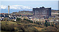
Inverclyde Royal Hospital
Viewed through Spango Valley from Idzholm Hill.
Image: © Thomas Nugent
Taken: 1 Apr 2013
0.18 miles