IMAGES TAKEN NEAR TO
Cockrobin Drive, PA16 0WE
Introduction
This page details the photographs taken nearby to Cockrobin Drive, PA16 0WE by members of the Geograph project.
The Geograph project started in 2005 with the aim of publishing, organising and preserving representative images for every square kilometre of Great Britain, Ireland and the Isle of Man.

There are currently over 7.5m images from over14,400 individuals and you can help contribute to the project by visiting https://www.geograph.org.uk
Image Map
Images are licensed for reuse under creativecommons.org/licenses/by-sa/2.0
Notes
- Clicking on the map will re-center to the selected point.
- The higher the marker number, the further away the image location is from the centre of the postcode.
Image Listing (73 Images Found)
Images are licensed for reuse under creativecommons.org/licenses/by-sa/2.0
Image
Details
Distance
1
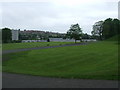
Ravenscraig Hospital grounds
Ravenscraig is set in extensive parkland style grounds.
Image: © Thomas Nugent
Taken: 5 Jun 2008
0.06 miles
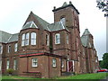
2
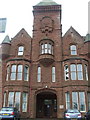
Ravenscraig Hospital
The main entrance to the older part of the hospital complex.
Image: © Thomas Nugent
Taken: 5 Jun 2008
0.09 miles
3
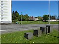
Metal blocks beside Inverkip Road
They are near the junction of Image and Image (shown crossing the image). Part of Image is in the left background.
Image: © Lairich Rig
Taken: 16 May 2018
0.09 miles
5
Ravenscraig Hospital
Part of the main hospital building.
Image: © Thomas Nugent
Taken: 5 Jun 2008
0.11 miles
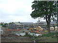
6
New housing at Branchton
Branchton is a council housing scheme in south west Greenock. See also Image
Image: © Thomas Nugent
Taken: 5 Jun 2008
0.11 miles
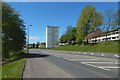
7
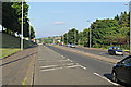
The A78 Inverkip Road
Looking towards Greenock town centre from the Gleninver Road junction.
Image: © Thomas Nugent
Taken: 10 Jul 2013
0.11 miles
8
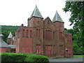
Ravenscraig Hospital
Many of the older red sandstone parts of the hospital are now closed and boarded up. The hospital opened in 1879 as Smithston Poorhouse and Asylum, changing to Ravenscraig Hospital with nationalisation in 1948.
The entire hospital was taken over by the Royal Canadian Navy as their headquarters in the Clyde estuary area during WWII.
Image: © Thomas Nugent
Taken: 5 Jun 2008
0.11 miles
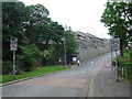
9
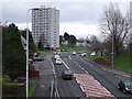
Inverkip Road
The A78 towards the centre of Greenock, viewed from the footbridge near Branchton Station. The high rise block is Ravenscraig Court.
Image: © Thomas Nugent
Taken: 23 Dec 2008
0.11 miles
10
New housing at Branchton
Viewed from Ravenscraig Hospital access road. See also Image
Image: © Thomas Nugent
Taken: 5 Jun 2008
0.11 miles