IMAGES TAKEN NEAR TO
The Glebe, GREENOCK, PA16 0GS
Introduction
This page details the photographs taken nearby to The Glebe, PA16 0GS by members of the Geograph project.
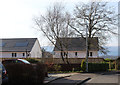
The Geograph project started in 2005 with the aim of publishing, organising and preserving representative images for every square kilometre of Great Britain, Ireland and the Isle of Man.

There are currently over 7.5m images from over14,400 individuals and you can help contribute to the project by visiting https://www.geograph.org.uk
Image Map
Images are licensed for reuse under creativecommons.org/licenses/by-sa/2.0
Notes
- Clicking on the map will re-center to the selected point.
- The higher the marker number, the further away the image location is from the centre of the postcode.
Image Listing (325 Images Found)
Images are licensed for reuse under creativecommons.org/licenses/by-sa/2.0
Image
Details
Distance
1
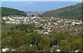
Swallow Brae
Viewed from Berfern Plantation.
Image: © Thomas Nugent
Taken: 7 Oct 2011
0.02 miles
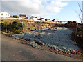
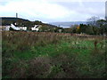
2
The Glebe, Inverkip
The old graveyard is beyond the trees. The Firth of Clyde can be seen in the distance.
Image: © Thomas Nugent
Taken: 7 Nov 2007
0.02 miles
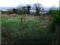
3
Building site on Millhouse Road
32 houses will be built on this site Between Inverkip cemetery, Langhouse and Langhouse Place, which can be seen in the background.
Image: © Thomas Nugent
Taken: 31 Mar 2019
0.03 miles
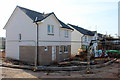
4
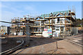
New houses off Langhouse Road
On former glebe land between the cemetery and Langhouse Avenue.
Image: © Thomas Nugent
Taken: 22 Mar 2020
0.03 miles
5
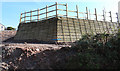
Building site on Millhouse Road
A timber clad retaining wall on the site where 32 houses are under construction.
Image: © Thomas Nugent
Taken: 22 Mar 2020
0.03 miles
6
The Glebe, Inverkip
Glebe land between Langhouse Road and Millhouse Road belonging to Inverkip Church. Innellan is visible across the Clyde in the distance.
Image: © Thomas Nugent
Taken: 7 Nov 2007
0.03 miles
7
New houses off Langhouse Road
On former glebe land. See the scene in 2007 before the houses were built Image
Image: © Thomas Nugent
Taken: 22 Mar 2020
0.04 miles
8
The Glebe
New houses on former glebe land (owned by the church, for the benefit of the church) off Langhouse Road.
Image: © Thomas Nugent
Taken: 23 Aug 2023
0.04 miles
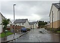
9
New houses off Langhouse Road
On former glebe land, viewed from Langhouse Place.
Image: © Thomas Nugent
Taken: 22 Mar 2020
0.04 miles
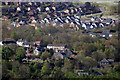
10
Inverkip from Bargane Hill
The old village and graveyard are in the foreground. The new houses in the background are at the Hill Farm estates. Note all the recently planted saplings in the top right corner.
Image: © Thomas Nugent
Taken: 29 Apr 2012
0.04 miles