IMAGES TAKEN NEAR TO
Primrose Crescent, GREENOCK, PA16 0DF
Introduction
This page details the photographs taken nearby to Primrose Crescent, PA16 0DF by members of the Geograph project.
The Geograph project started in 2005 with the aim of publishing, organising and preserving representative images for every square kilometre of Great Britain, Ireland and the Isle of Man.

There are currently over 7.5m images from over14,400 individuals and you can help contribute to the project by visiting https://www.geograph.org.uk
Image Map
Images are licensed for reuse under creativecommons.org/licenses/by-sa/2.0
Notes
- Clicking on the map will re-center to the selected point.
- The higher the marker number, the further away the image location is from the centre of the postcode.
Image Listing (255 Images Found)
Images are licensed for reuse under creativecommons.org/licenses/by-sa/2.0
Image
Details
Distance
1
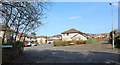
Millhouse Road
Swallow Brae is on the left, the slightly re-aligned Millhouse Road continues to the right.
Image: © Thomas Nugent
Taken: 22 Mar 2020
0.05 miles
2
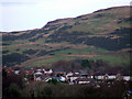
Swallow Brae and Cauldron Hill
Viewed from the railway station footbridge.
Image: © Thomas Nugent
Taken: 31 Dec 2012
0.08 miles
3
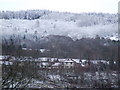
Swallow Brae and Leapmoor Forest
Since the trees were harvested at Bridgend last year, Swallow Brae can now be seen from Ardgowan Estate. Snow covered Leapmoor Forest is in the distance.
Image: © Thomas Nugent
Taken: 3 Mar 2008
0.08 miles
4
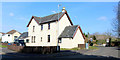
Millhouse Road
Looking up the hill near the cemetery. New houses are under construction on the former glebe land on the right.
Image: © Thomas Nugent
Taken: 22 Mar 2020
0.08 miles
5

Inverkip and Kip Marina
Viewed from the track at Langhill Farm.
Image: © Thomas Nugent
Taken: 30 Apr 2018
0.10 miles
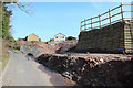
6
Bogside Farm
A former working farmhouse on Millhouse Road.
Image: © Thomas Nugent
Taken: 22 Mar 2020
0.10 miles
7
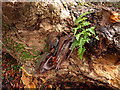
Fungus and Fern
On dead tree Millhouse Road, Inverkip Image
Image: © wfmillar
Taken: 24 Nov 2010
0.10 miles
8
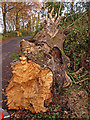
Millhouse Road, Inverkip
Fallen tree looks like it has been dead for years and has finally succumbed to the wind. The stump is on the right.CompareImage
Image: © wfmillar
Taken: 24 Nov 2010
0.10 miles
10

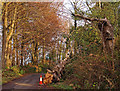
Millhouse Gait
Off Millhouse Road, on the site of Bogside farmyard.
Image: © Thomas Nugent
Taken: 6 Apr 2015
0.11 miles