IMAGES TAKEN NEAR TO
Inverkip, GREENOCK, PA16 0DA
Introduction
This page details the photographs taken nearby to PA16 0DA by members of the Geograph project.
The Geograph project started in 2005 with the aim of publishing, organising and preserving representative images for every square kilometre of Great Britain, Ireland and the Isle of Man.

There are currently over 7.5m images from over14,400 individuals and you can help contribute to the project by visiting https://www.geograph.org.uk
Image Map
Images are licensed for reuse under creativecommons.org/licenses/by-sa/2.0
Notes
- Clicking on the map will re-center to the selected point.
- The higher the marker number, the further away the image location is from the centre of the postcode.
Image Listing (128 Images Found)
Images are licensed for reuse under creativecommons.org/licenses/by-sa/2.0
Image
Details
Distance
1

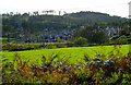
Berfern farm
On Finnockbog Road, near Finnock Bog Farm.
Image: © Thomas Nugent
Taken: 20 Aug 2007
0.02 miles
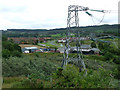
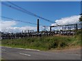
2
Transformers at Berfern
Between the disused Inverkip Power Station and the National Grid.
Image: © Thomas Nugent
Taken: 7 Oct 2011
0.04 miles
3

Berfern Farm
Viewed from Berfern Plantation.
Image: © Thomas Nugent
Taken: 7 Oct 2011
0.04 miles
4
New housing estate
Currently under construction on former greenbelt land at Hill Farm.
Image: © Thomas Nugent
Taken: 7 Nov 2008
0.04 miles
5
Berfern Farm
Viewed from behind the electricity sub station.
Image: © Thomas Nugent
Taken: 17 Jul 2012
0.04 miles
6
Bang goes the green belt
The beginning of the end for the designated greenbelt land to the south of Inverkip railway station.
Image: © Thomas Nugent
Taken: 20 Aug 2007
0.05 miles
7

Fields at Berfern Farm
These fields have thus far eluded the housing developers. Leapmoor Forest is on the horizon.
Image: © Thomas Nugent
Taken: 7 Oct 2011
0.06 miles
8

Warning notice at Spey Road
Not as it might appear at first glance a coronavirus (covid-19) warning notice, but a Croma Security warning notice.
Croma web site: https://www.cssgplc.com/ .
Image: © Thomas Nugent
Taken: 21 Mar 2020
0.07 miles
9
Electrical substation
For power from Inverkip power station (disused).
Image: © william craig
Taken: 1 Aug 2005
0.07 miles
10
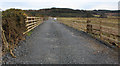
Track off Spey Road
The track was recently upgraded to enable removal of the pylon line which ran from here, over the moors to paisley.
Image: © Thomas Nugent
Taken: 21 Mar 2020
0.07 miles