IMAGES TAKEN NEAR TO
Balloch Road, GREENOCK, PA15 3ES
Introduction
This page details the photographs taken nearby to Balloch Road, PA15 3ES by members of the Geograph project.
The Geograph project started in 2005 with the aim of publishing, organising and preserving representative images for every square kilometre of Great Britain, Ireland and the Isle of Man.

There are currently over 7.5m images from over14,400 individuals and you can help contribute to the project by visiting https://www.geograph.org.uk
Image Map
Images are licensed for reuse under creativecommons.org/licenses/by-sa/2.0
Notes
- Clicking on the map will re-center to the selected point.
- The higher the marker number, the further away the image location is from the centre of the postcode.
Image Listing (31 Images Found)
Images are licensed for reuse under creativecommons.org/licenses/by-sa/2.0
Image
Details
Distance
1
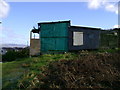
Doocot perched above housing estate
This doocot is on some marginal land between a residential area and rough grazing land.
Image: © Mark Nightingale
Taken: 5 Feb 2007
0.06 miles
2
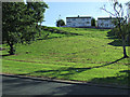
Houses on Leven Road
Viewed from Kilmacolm Road.
Image: © Thomas Nugent
Taken: 7 Sep 2014
0.08 miles
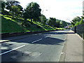
4
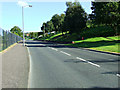
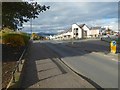
Kilmacolm Road
The B788 road, climbing through the east end of Greenock.
Image: © Thomas Nugent
Taken: 7 Sep 2014
0.12 miles
5
Kilmacolm Road
The B788 road, descending into Greenock.
Image: © Thomas Nugent
Taken: 7 Sep 2014
0.13 miles
6
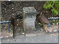
Old boundary stone
The full inscription on the stone is:
"Burgh of Greenock Boundary 1877"
The "Greenock Boundary 1877" part is clearly legible in the picture.
The stone is in its original position alongside Image; see that photograph for context. The stone is later than the first-edition OS map, but is shown on the second-edition map of c.1897.
Another Burgh boundary stone, of a different shape, but also dating from 1877, can be seen elsewhere in Greenock, near Image For views of it, see Image (close-up) and Image (in context).
Image: © Lairich Rig
Taken: 4 Jul 2011
0.16 miles
7
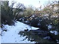
Burn in Auchmountain Glen
The glen was a popular recreation spot during the 1930s depression, but the facilities there have now gone or fallen into disrepair.
Image: © Thomas Nugent
Taken: 11 Feb 2009
0.16 miles
8
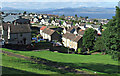
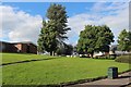
Greenock east end
Looking over the east end from Kilmacolm Road, with Helensburgh and the Firth of Clyde in the distance.
Image: © Thomas Nugent
Taken: 7 Sep 2014
0.16 miles
9
Kilmacolm Road
The area on the right had been redeveloped in recent years; compare Image, taken a few years earlier. In both pictures, an old boundary stone can be seen not far ahead, just to the left of the pavement. In the present picture, taken when the sun was low, it is in shadow. It is shown in Image
For another view of the new houses that are on the other side of the road, see Image
Image: © Lairich Rig
Taken: 24 Oct 2016
0.16 miles
10
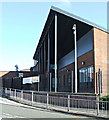
All Saints Primary School
On Blairmore Road. One of the many new school buildings which have been built in Invercyde in recent years.
Image: © Thomas Nugent
Taken: 7 Sep 2014
0.17 miles