IMAGES TAKEN NEAR TO
Aberfoyle Road, GREENOCK, PA15 3DF
Introduction
This page details the photographs taken nearby to Aberfoyle Road, PA15 3DF by members of the Geograph project.
The Geograph project started in 2005 with the aim of publishing, organising and preserving representative images for every square kilometre of Great Britain, Ireland and the Isle of Man.

There are currently over 7.5m images from over14,400 individuals and you can help contribute to the project by visiting https://www.geograph.org.uk
Image Map
Images are licensed for reuse under creativecommons.org/licenses/by-sa/2.0
Notes
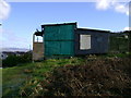
- Clicking on the map will re-center to the selected point.
- The higher the marker number, the further away the image location is from the centre of the postcode.
Image Listing (44 Images Found)
Images are licensed for reuse under creativecommons.org/licenses/by-sa/2.0
Image
Details
Distance
1
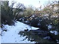
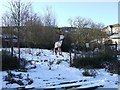
Burn in Auchmountain Glen
The glen was a popular recreation spot during the 1930s depression, but the facilities there have now gone or fallen into disrepair.
Image: © Thomas Nugent
Taken: 11 Feb 2009
0.12 miles
2
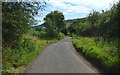
Road leading from a covered reservoir
The continuation of this road through a built-up area not far down the hill is called Glenbrae Road on the map. For a view in the opposite direction, see Image
Image: © Lairich Rig
Taken: 24 Jul 2017
0.15 miles
3
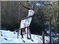
Reindeer sculpture
At the Kilmacolm Road end of Auchmountain Glen.
Image: © Thomas Nugent
Taken: 11 Feb 2009
0.16 miles
4
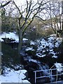
Burn in Auchmountain Glen
The burn enters a culvert at this point and disappears from view.
Image: © Thomas Nugent
Taken: 11 Feb 2009
0.16 miles
5
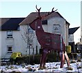
Reindeer sculpture
Shedding graffiti tears, by Kilmacolm Road.
Image: © Thomas Nugent
Taken: 11 Feb 2009
0.16 miles
6
Monarch of the glen
A steel reindeer sculpture at the Kilmacolm Road end of Auchmountain Glen.
Image: © Thomas Nugent
Taken: 11 Feb 2009
0.16 miles
7
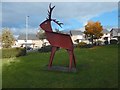
Reindeer sculpture
The picture was taken in an Image Earlier pictures show the same sculpture in more wintry conditions: Image / Image / Image
Image: © Lairich Rig
Taken: 24 Oct 2016
0.18 miles
8
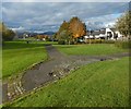
Open space beside Kilmacolm Road
A Image is out of shot to the right. The houses visible on the right stand on the other side of Kilmacolm Road.
Image: © Lairich Rig
Taken: 24 Oct 2016
0.18 miles
9
Doocot perched above housing estate
This doocot is on some marginal land between a residential area and rough grazing land.
Image: © Mark Nightingale
Taken: 5 Feb 2007
0.18 miles
10
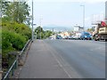
Kilmacolm Road
The photograph was taken to provide context for an Image which can be seen in the foreground, on the left.
The scaffolding on the right is associated with demolition work taking place here as part of a £22 million housing development. Image can be seen in the distance; it is more clearly visible in Image, which was taken further down the hill.
For a view similar to the present picture, but taken a few years later, long after the redevelopment work was complete, see Image; the boundary stone can also be seen in that picture, although it is in shadow.
Image: © Lairich Rig
Taken: 4 Jul 2011
0.19 miles