IMAGES TAKEN NEAR TO
Finnieston Street, GREENOCK, PA15 2LD
Introduction
This page details the photographs taken nearby to Finnieston Street, PA15 2LD by members of the Geograph project.
The Geograph project started in 2005 with the aim of publishing, organising and preserving representative images for every square kilometre of Great Britain, Ireland and the Isle of Man.

There are currently over 7.5m images from over14,400 individuals and you can help contribute to the project by visiting https://www.geograph.org.uk
Image Map
Images are licensed for reuse under creativecommons.org/licenses/by-sa/2.0
Notes
- Clicking on the map will re-center to the selected point.
- The higher the marker number, the further away the image location is from the centre of the postcode.
Image Listing (275 Images Found)
Images are licensed for reuse under creativecommons.org/licenses/by-sa/2.0
Image
Details
Distance
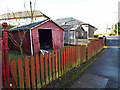
1
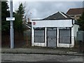
Disused shop
On Bawhirley Road at the junction of Strone Crescent.
Image: © Thomas Nugent
Taken: 27 Feb 2009
0.04 miles
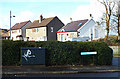
2
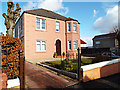
House on Bawhirley Road
One of several attractive villas on Bawhirley Road. This one is at the corner of Finnieston Street.
Image: © Thomas Nugent
Taken: 1 Mar 2014
0.04 miles
3
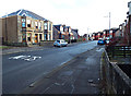
Bawhirley Road
The top of the hill, near Strone Crescent.
Image: © Thomas Nugent
Taken: 1 Mar 2014
0.04 miles
4
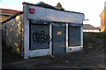
Disused shop
On Bawhirley Road at Strone Crescent.
Image: © Thomas Nugent
Taken: 1 Mar 2013
0.05 miles
5
Bawhirley Road
Lockup garages at the top of the hill, near Strone Crescent.
Image: © Thomas Nugent
Taken: 1 Mar 2014
0.05 miles
6
Strone Crescent
At the junction with Bawhirley Road.
Image: © Thomas Nugent
Taken: 1 Mar 2014
0.06 miles
7
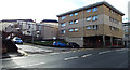
Belville Street at Belville Avenue
Owing to its close proximity to the shipyards and several railway lines, much of the street was destroyed during the Greenock Blitz in 1941. These buildings must have appeared futuristic when they were built.
Image: © Thomas Nugent
Taken: 1 Mar 2014
0.07 miles
8
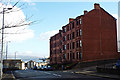
Belville Street
Red sandstone tenements (survivors of the 1941 Greenock Blitz) at the junction with Belville Avenue. The crane in the distance is at James Watt Dock Image
Image: © Thomas Nugent
Taken: 1 Mar 2014
0.07 miles
9
Belville Street
Contrasting styles of tenements on the south side of Belville Street at Belville Avenue.
Image: © Thomas Nugent
Taken: 1 Mar 2013
0.08 miles
10

Belville Street
Owing to its close proximity to the shipyards and several railway lines, much of the street was destroyed during the Greenock Blitz in 1941. These buildings must have appeared futuristic when they were built.
Image: © Thomas Nugent
Taken: 1 Mar 2014
0.08 miles