IMAGES TAKEN NEAR TO
Bawhirley Road, GREENOCK, PA15 2BQ
Introduction
This page details the photographs taken nearby to Bawhirley Road, PA15 2BQ by members of the Geograph project.
The Geograph project started in 2005 with the aim of publishing, organising and preserving representative images for every square kilometre of Great Britain, Ireland and the Isle of Man.

There are currently over 7.5m images from over14,400 individuals and you can help contribute to the project by visiting https://www.geograph.org.uk
Image Map (Loading...)


Getting Data...Please wait
Leaflet Map data © OpenStreetMap
Images are licensed for reuse under creativecommons.org/licenses/by-sa/2.0
Notes
- Clicking on the map will re-center to the selected point.
- The higher the marker number, the further away the image location is from the centre of the postcode.
Image Listing (238 Images Found)
Images are licensed for reuse under creativecommons.org/licenses/by-sa/2.0
Image
Details
Distance
2
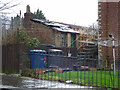
An old wash house
Behind a house on East Crawford Street, viewed from Bawhirley Road.
Image: © Thomas Nugent
Taken: 22 Feb 2019
0.02 miles
3
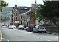
Bawhirley Road
Looking up the steep hill that is Bawhirley Road from Cartsdyke station.
Image: © Thomas Nugent
Taken: 6 Sep 2010
0.03 miles
4

East Crawford Street
Substantial semi-detached sandstone villas at the junction with Bawhirley Road.
Image: © Thomas Nugent
Taken: 22 Feb 2019
0.03 miles
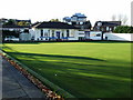
5
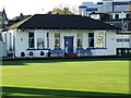
Victoria Bowling Club
At the top of Ratho Street. Opened in June 1897. More information here http://homepage.ntlworld.com/ian.mca/latestnews.htm
Image: © Thomas Nugent
Taken: 23 Nov 2007
0.03 miles
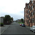
6
East Crawford Street
Looking along the street from the top of Ratho Street.
Image: © Thomas Nugent
Taken: 6 Sep 2010
0.03 miles
7
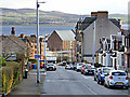
Bawhirley Road
Looking down the hill towards the sugar sheds at James Watt Dock.
Image: © Thomas Nugent
Taken: 27 Jan 2020
0.05 miles
8
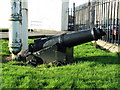
Victoria Bowling Club cannon
Points down Ratho Street from the stairs at the front of the green. History unknown.
Image: © Thomas Nugent
Taken: 23 Nov 2007
0.05 miles
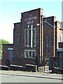
9
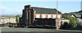
Salvation Army building
On the lower part of Bawhirley Road.
Image: © Thomas Nugent
Taken: 7 Sep 2014
0.06 miles
10
Salvation Army building
On the lower part of Bawhirley Road.
Image: © Thomas Nugent
Taken: 7 Sep 2014
0.06 miles