IMAGES TAKEN NEAR TO
Douglas Rae Road, GREENOCK, PA15 2AB
Introduction
This page details the photographs taken nearby to Douglas Rae Road, PA15 2AB by members of the Geograph project.
The Geograph project started in 2005 with the aim of publishing, organising and preserving representative images for every square kilometre of Great Britain, Ireland and the Isle of Man.

There are currently over 7.5m images from over14,400 individuals and you can help contribute to the project by visiting https://www.geograph.org.uk
Image Map
Images are licensed for reuse under creativecommons.org/licenses/by-sa/2.0
Notes
- Clicking on the map will re-center to the selected point.
- The higher the marker number, the further away the image location is from the centre of the postcode.
Image Listing (603 Images Found)
Images are licensed for reuse under creativecommons.org/licenses/by-sa/2.0
Image
Details
Distance
1
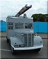
Austin K2 Auxiliary Towing Vehicle
This Austin K2 Auxiliary Towing Vehicle (ATV) (Registration GGX 583) was originally built in 1941 and has been restored by the Strathclyde Fire and Rescue Preservation Group http://www.strathclydefirepreservationgroup.org/projects/GGX_583_Pr.htm
Image: © Andy Farrington
Taken: 10 Jul 2011
0.00 miles
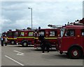
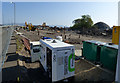
2
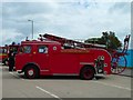
Western Area Fire Brigade
Several old fire tenders were on display as a part of the Tall Ships Race Festival at Greenock.
Image: © Andy Farrington
Taken: 10 Jul 2011
0.00 miles
3
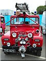
Austin Gipsy
This Austin Gipsy (Registration THS 825) is a light pump 4x4 and was made in 1961.
Image: © Andy Farrington
Taken: 10 Jul 2011
0.00 miles
4
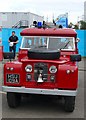
Land Rover Redwing
This Land Rover Redwing (Registration HSU 109A) is a light pump 4x4 and was made in 1962.
Image: © Andy Farrington
Taken: 10 Jul 2011
0.00 miles
5
Fire Tenders
Several old fire tenders were on display as a part of the Tall Ships Race Festival at Greenock.
Image: © Andy Farrington
Taken: 10 Jul 2011
0.01 miles
6
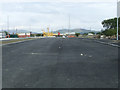
New road at James Watt Dock
At the east end of the dock. This will be the main access road to the new housing development at the dock and the Great Harbour which is in the background.
Image: © Thomas Nugent
Taken: 6 Sep 2010
0.01 miles
7
New road at James Watt Dock
At the east end of the dock. This will be the main access road to the new housing development at the dock and the Great Harbour which is in the background.
Image: © Thomas Nugent
Taken: 6 Sep 2010
0.01 miles
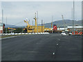
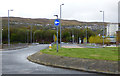
8
Douglas Rae Road
The road was named in honour of the late Douglas Rae who was chairman and sponsor of Greenock Morton FC. One of the floodlight pylons at Mortom's Cappielow ground can be seen in the background. The road links the A8 Dual carriageway East Hamilton Street with the Great Harbour and James Watt Dock.
Image: © Thomas Nugent
Taken: 22 Apr 2019
0.01 miles
9
Building site at James Watt Dock
A new housing development on former industrial/dockland land on the east side of Douglas Rae Road.
Image: © Thomas Nugent
Taken: 22 Apr 2019
0.02 miles
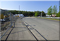
10
Access road at James Watt Dock
Still unnamed several years after opening, this short dual carriageway road off the A8 East Hamilton Street was built to encourage development of the dock area, most of which is still in a brownfield state.
Image: © Thomas Nugent
Taken: 1 May 2016
0.02 miles