IMAGES TAKEN NEAR TO
Cross Shore Street, GREENOCK, PA15 1DU
Introduction
This page details the photographs taken nearby to Cross Shore Street, PA15 1DU by members of the Geograph project.
The Geograph project started in 2005 with the aim of publishing, organising and preserving representative images for every square kilometre of Great Britain, Ireland and the Isle of Man.

There are currently over 7.5m images from over14,400 individuals and you can help contribute to the project by visiting https://www.geograph.org.uk
Image Map
Images are licensed for reuse under creativecommons.org/licenses/by-sa/2.0
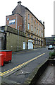
Notes
- Clicking on the map will re-center to the selected point.
- The higher the marker number, the further away the image location is from the centre of the postcode.
Image Listing (816 Images Found)
Images are licensed for reuse under creativecommons.org/licenses/by-sa/2.0
Image
Details
Distance
1
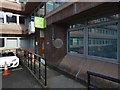
Cross Shore Street
The west side of the former GPO building, which is now the James Watt Bar.
Image: © Thomas Nugent
Taken: 2 Nov 2015
0.02 miles
2
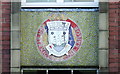
Former Sailors' Centre
The Inverclyde coat of arms covers the original mosaic above the main entrance to the building. See also Image
Image: © Thomas Nugent
Taken: 9 Nov 2007
0.02 miles
3
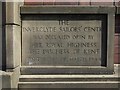
Inscription on the former Inverclyde Sailors' Centre
Image: © Lairich Rig
Taken: 16 May 2018
0.03 miles
4
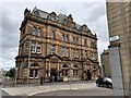
The James Watt
Nowadays the building is occupied by a Wetherspoon restaurant named the James Watt. The building was opened in 1899 as the town’s general post office.
Image: © Chris Thomas-Atkin
Taken: 4 Jul 2019
0.03 miles
5
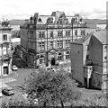
The James Watt - JD Wetherspoon (Public House)
This ornate building in Cathcart Street was designed as Greenock's general post office by Walter W. Robertson (1845-1907). Built at a cost of £20,000, it was officially opened on 22 May 1899.
The premises are now named after James Watt, the inventor and mechanical engineer born in Greenock in 1736. His improvements to the steam engine powered the Industrial Revolution which changed the world. Watt also introduced the word horsepower – to indicate an engine’s power.
Image: © Raibeart MacAoidh
Taken: 1 Aug 2024
0.03 miles
6
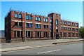
The former Inverclyde Sailors' Centre
For earlier pictures and for more about the building's use, past and present, see Image and Image
For two smaller details, see Image and Image
Image: © Lairich Rig
Taken: 16 May 2018
0.03 miles
7
East Breast sign
Marks the spot of the former East Dock Breast at Dalrymple Street.
Image: © Thomas Nugent
Taken: 31 Dec 2009
0.03 miles
8
Former Inverclyde Sailors' Centre
On Dalrymple Street. Now a social work centre.
Image: © Thomas Nugent
Taken: 23 Aug 2014
0.03 miles
9
Plaque marking the site of the Long Well
The plaque is number 17 on the Central Greenock Statues Trail. It is in an out-of-the-way spot, on an office building that can be accessed by a lane leading off Cathcart Street. The lane used to be (and perhaps still is) called Duff Street, although the office building shown here now blocks off its northern end.
Duff Street, named after one of the town's Bailies, replaced the earlier Longwell Close, a very old thoroughfare, which was eventually condemned and demolished.
The site of the Long Well on Duff Street used to be (in the early years of the twentieth century) marked by a flagstone, which, like the plaque in the present image, bore the inscription "The Long Well, 1682".
George Williamson, on pages 30–32 of his "Old Greenock ..." (1886), quotes an old charter of 1683, which mentions a certain James Johnstoune and "the well builded be him and uthers his neighbours upon their owne charges". Williamson notes that "it was evidently in connection with James Johnstone's well that the name Longwell was given to the Closs or Lane leading from Cathcart Street to Shaw Street, from whence by a slight deflection access is gained to the Harbour, formerly the sea shore".
He goes on to record that "some old residenters assert that the 'Long Well' is fifty, others sixty, feet deep. This we can well credit. It is satisfactory to state that in the course of the operations of the Improvement Trust in removing the old houses in the Closs for the formation of what is now known as Duff Street a deep well has been discovered, which fully answers the description above given." Williamson goes on to give an account of its discovery and its dimensions.
As for the flagstone mentioned earlier, it was set in the ground, about halfway along Duff Street (and therefore near where the modern plaque is located); I presume that the flagstone was removed in connection with later construction work on that street (either in connection with this office block, or at an earlier time). The plaque in the picture is clearly modern.
Image: © Lairich Rig
Taken: 3 Oct 2016
0.03 miles
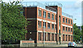
10
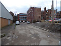
East Breast
Looking towards Dalrymple Street and the rear of the former Inverclyde Sailors' Centre.
Image: © Thomas Nugent
Taken: 29 Dec 2016
0.03 miles