IMAGES TAKEN NEAR TO
Greenock Road, PORT GLASGOW, PA14 6XY
Introduction
This page details the photographs taken nearby to Greenock Road, PA14 6XY by members of the Geograph project.
The Geograph project started in 2005 with the aim of publishing, organising and preserving representative images for every square kilometre of Great Britain, Ireland and the Isle of Man.

There are currently over 7.5m images from over14,400 individuals and you can help contribute to the project by visiting https://www.geograph.org.uk
Image Map (48 Images)


Getting Data...Please wait
Leaflet Map data © OpenStreetMap
Images are licensed for reuse under creativecommons.org/licenses/by-sa/2.0
Notes
- Clicking on the map will re-center to the selected point.
- The higher the marker number, the further away the image location is from the centre of the postcode.
Image Listing (48 Images Found)
Images are licensed for reuse under creativecommons.org/licenses/by-sa/2.0
Image
Details
Distance
1
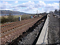
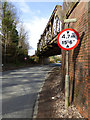
Landslide remedial works
A landslide closed the Glasgow to Gourock & Wemyss Bay railway line here in January 2011. The A8 passes close on the right and is partially closed and controlled by lights while the landslide is made good. The repairs will take several months to complete as the working hours are restricted to three hours each night due to train movements and the need to switch off the overhead power lines.
Image: © Thomas Nugent
Taken: 18 Mar 2011
0.04 miles
2
Landslide remedial works
A landslide closed the Glasgow to Gourock & Wemyss Bay railway line here in January 2011. The A8 passes close on the right and is partially closed and controlled by lights while the landslide is made good. The repairs will take several months to complete as the working hours are restricted to three hours each night due to train movements and the need to switch off the overhead power lines.
Image: © Thomas Nugent
Taken: 18 Mar 2011
0.04 miles
3
Landslide remedial works
A landslide closed the Glasgow to Gourock & Wemyss Bay railway line here in January 2011. The A8 passes close on the left and is partially closed and controlled by lights while the landslide is made good. The repairs will take several months to complete as the working hours are restricted to three hours each night due to train movements and the need to switch off the overhead power lines.
Image: © Thomas Nugent
Taken: 18 Mar 2011
0.04 miles
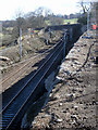
4
Landslide remedial works
The A8 runs above the Glasgow to Gourock & Wemyss Bay railway line, just behind the red barriers which mark the area of the landslide. See also Image & Image
Image: © Thomas Nugent
Taken: 23 Jan 2011
0.07 miles
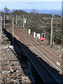
5
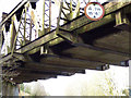
Westferry railway bridge
The girder bridge carries the Glasgow to Gourock and Wemyss Bay line over the A8 Greenock Road at the foot of Hatton Brae (Bishopton Brae). This view shows the underside of the deck.
Image: © Thomas Nugent
Taken: 25 Mar 2019
0.08 miles
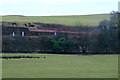
6
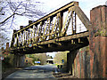
Westferry railway bridge
The girder bridge carries the Glasgow to Gourock and Wemyss Bay line over the A8 Greenock Road at the foot of Hatton Brae (Bishopton Brae). This is the south side of the bridge.
Image: © Thomas Nugent
Taken: 25 Mar 2019
0.08 miles
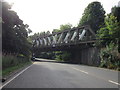
7
Westferry railway bridge
The girder bridge carries the Glasgow to Gourock and Wemyss Bay line over the A8 Greenock Road at the foot of Hatton Brae (Bishopton Brae). This is the south side of the bridge.
Image: © Thomas Nugent
Taken: 25 Mar 2019
0.08 miles
10
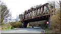
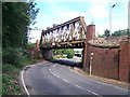
Westferry railway bridge
The girder bridge carries the Glasgow to Gourock and Wemyss Bay line over the A8 Greenock Road at the foot of Hatton Brae (Bishopton Brae). This is the north side of the bridge.
Image: © Thomas Nugent
Taken: 25 Mar 2019
0.09 miles