IMAGES TAKEN NEAR TO
Greenock Road, PORT GLASGOW, PA14 6TR
Introduction
This page details the photographs taken nearby to Greenock Road, PA14 6TR by members of the Geograph project.
The Geograph project started in 2005 with the aim of publishing, organising and preserving representative images for every square kilometre of Great Britain, Ireland and the Isle of Man.

There are currently over 7.5m images from over14,400 individuals and you can help contribute to the project by visiting https://www.geograph.org.uk
Image Map
Images are licensed for reuse under creativecommons.org/licenses/by-sa/2.0
Notes
- Clicking on the map will re-center to the selected point.
- The higher the marker number, the further away the image location is from the centre of the postcode.
Image Listing (133 Images Found)
Images are licensed for reuse under creativecommons.org/licenses/by-sa/2.0
Image
Details
Distance

3
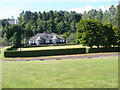
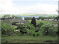
Parklea Bowling Club
Once part of a thriving park which included a putting green and tennis courts which were removed in the early 1980s to make way for the realigned A8.
Image: © Thomas Nugent
Taken: 6 Jun 2008
0.01 miles
4
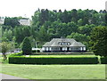
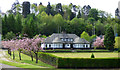
Parklea Pavilion
Parklea Pavilion, home to Parklea Bowling Club, was the main building in King George V Park. Some Woodhall residents were evacuated here during the war following bomb damage to their houses during the 1941 blitz which resulted in thirty deaths in nearby Woodhall Terrace.
The tennis courts, putting green and swingpark are long gone, under the re-aligned A8 road, but the bowling club and the adjacent football pitches still thrive.
Image: © Thomas Nugent
Taken: 11 May 2016
0.01 miles
5
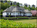
Parklea Pavilion
Parklea Pavilion, home to Parklea Bowling Club, was the main building in King George V Park. Some Woodhall residents were evacuated here during the war following bomb damage to their houses during the 1941 blitz which resulted in thirty deaths in nearby Woodhall Terrace.
The tennis courts, putting green and swingpark are long gone, under the re-aligned A8 road, but the bowling club and the adjacent football pitches still thrive.
Image: © Thomas Nugent
Taken: 11 May 2016
0.01 miles
6
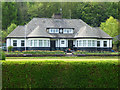
Bowling club by Parklea roundabout
The rear of Parklea Bowling Clubhouse.
Image: © John Firth
Taken: 13 May 2011
0.01 miles
7
Parklea Bowling Club
Parklea Pavilion, home to Parklea Bowling Club, was the main building in King George V Park. Some Woodhall residents were evacuated here during the war following bomb damage to their houses during the 1941 blitz which resulted in thirty deaths in nearby Woodhall Terrace.
The tennis courts, putting green and swingpark are long gone, under the re-aligned A8 road, but the bowling club and the adjacent football pitches still thrive.
Image: © Thomas Nugent
Taken: 11 May 2016
0.01 miles
8
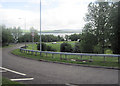
Parklea Road at A8 Junction at Woodhall
This is a roundabout at this junction.
Image: © John Firth
Taken: 13 May 2011
0.04 miles
9
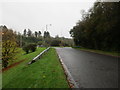
Approaching Greenock Road roundabout
Image: © Jonathan Thacker
Taken: 31 Oct 2017
0.05 miles
10
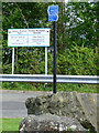
Signs at Parklea
Informing the visitor who has arrived from the nearby Parklea roundabout on the A8 dual carriageway.
Image: © Thomas Nugent
Taken: 11 May 2016
0.06 miles