IMAGES TAKEN NEAR TO
PA14 6QW
Introduction
This page details the photographs taken nearby to PA14 6QW by members of the Geograph project.
The Geograph project started in 2005 with the aim of publishing, organising and preserving representative images for every square kilometre of Great Britain, Ireland and the Isle of Man.

There are currently over 7.5m images from over14,400 individuals and you can help contribute to the project by visiting https://www.geograph.org.uk
Image Map
Images are licensed for reuse under creativecommons.org/licenses/by-sa/2.0
Notes
- Clicking on the map will re-center to the selected point.
- The higher the marker number, the further away the image location is from the centre of the postcode.
Image Listing (342 Images Found)
Images are licensed for reuse under creativecommons.org/licenses/by-sa/2.0
Image
Details
Distance
1
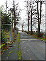
Mansion Avenue
St lower part of the avenue at Woodhall Square. Late 19th C maps show this as the road to the former Woodhall mansion which was located where St Martin's church now stands Image
Image: © Thomas Nugent
Taken: 2 Dec 2013
0.00 miles
2
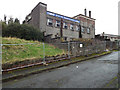
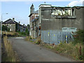
Former Woodhall Co-op store
The Mansion Avenue side of the general store on Brightside Avenue which later became the Riverside Resource Centre. Now vacant and awaiting demolition.
Image: © Thomas Nugent
Taken: 2 Dec 2013
0.01 miles
3
Former Woodhall Co-op store
The Mansion Avenue side of the general store on Brightside Avenue which later became the Riverside Resource Centre. Now vacant and awaiting demolition.
Image: © Thomas Nugent
Taken: 2 Dec 2013
0.01 miles
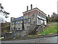
4
Former Woodhall Co-op store
The Mansion Avenue side of the general store on Brightside Avenue which later became the Riverside Resource Centre. Now vacant and awaiting demolition. The houses at this side of Brightside Avenue have all been demolished, revealing the rear of St Martin's church.
Image: © Thomas Nugent
Taken: 2 Dec 2013
0.01 miles
5
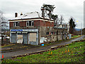
Former Woodhall Co-op store
The rear of the building, viewed from Brightside Avenue.
Image: © Thomas Nugent
Taken: 25 Aug 2014
0.01 miles
6
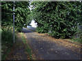
Mansion Avenue
Looking up the hill from Woodhall Square. This was the driveway to Woodhall Mansion which stood further up the hill.
See also Image
Image: © Thomas Nugent
Taken: 25 Aug 2014
0.01 miles
7
Former Woodhall Co-op store
The Mansion Avenue side of the general store on Brightside Avenue which later became the Riverside Resource Centre. Now vacant and awaiting demolition. The houses at this side of Brightside Avenue have all been demolished, revealing the rear of St Martin's church.
Image: © Thomas Nugent
Taken: 2 Dec 2013
0.01 miles
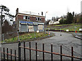
8
Former Woodhall Co-op store
On Brightside Avenue, now vacant and awaiting demolition. Was most recently used as Riverside Resource Centre.
Image: © Thomas Nugent
Taken: 2 Dec 2013
0.01 miles
9
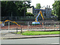
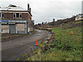
Woodhall Terrace building site
With the former Cooperative store at Brightside Avenue in the background.
Image: © Thomas Nugent
Taken: 25 Aug 2014
0.01 miles
10
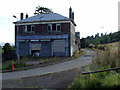
Former Woodhall Co-op store
On mansion Avenue at Brightside Avenue, which is to the right.
Image: © Thomas Nugent
Taken: 25 Aug 2014
0.01 miles