IMAGES TAKEN NEAR TO
Pladda Avenue, PORT GLASGOW, PA14 6EN
Introduction
This page details the photographs taken nearby to Pladda Avenue, PA14 6EN by members of the Geograph project.
The Geograph project started in 2005 with the aim of publishing, organising and preserving representative images for every square kilometre of Great Britain, Ireland and the Isle of Man.

There are currently over 7.5m images from over14,400 individuals and you can help contribute to the project by visiting https://www.geograph.org.uk
Image Map (Loading...)


Getting Data...Please wait
Leaflet Map data © OpenStreetMap
Images are licensed for reuse under creativecommons.org/licenses/by-sa/2.0
Notes
- Clicking on the map will re-center to the selected point.
- The higher the marker number, the further away the image location is from the centre of the postcode.
Image Listing (16 Images Found)
Images are licensed for reuse under creativecommons.org/licenses/by-sa/2.0
Image
Details
Distance
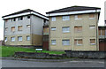
1
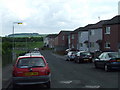
Pladda Avenue
Four blocks of flats stood in the area to the left until recently.
Image: © Thomas Nugent
Taken: 6 Jun 2008
0.01 miles
2
Rona Avenue
Viewed from the Oronsay Avenue end.
Image: © Thomas Nugent
Taken: 6 Jun 2008
0.06 miles
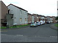
3
Oronsay Avenue
Looking towards Pladda Avenue.
Image: © Thomas Nugent
Taken: 6 Jun 2008
0.09 miles
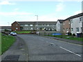
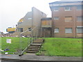
5
Oronsay Avenue
Part of the "banana block", a row of ten linked blocks of flats, built in the late 1960s, which is currently being demolished. These two are at the junction of Pladda Avenue.
Image: © Thomas Nugent
Taken: 26 Aug 2012
0.11 miles
6
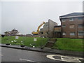
Demolition of flats in Oronsay Avenue Port Glasgow
Image: © John Ferguson
Taken: 17 Aug 2012
0.11 miles
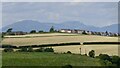
7
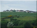
Park Farm
A council housing scheme in upper Port Glasgow. Viewed from Finlaystone Road at Auchendores Reservoir.
Image: © Thomas Nugent
Taken: 6 Jun 2008
0.12 miles
8
Demolition of flats in Oronsay Avenue Port Glasgow
Image: © John Ferguson
Taken: 17 Aug 2012
0.12 miles
9
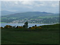
Cardross from Pladda Avenue
Part of Ben Lomond is visible to the right.
Image: © Thomas Nugent
Taken: 6 Jun 2008
0.13 miles
10
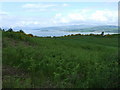
Field at Pladda Avenue
This was once grazing land for dairy cows from Parkhill Farm, but now appears to be derelict. Ardmore Peninsula, the Firth of Clyde and Cardross can be seen in the distance.
Image: © Thomas Nugent
Taken: 6 Jun 2008
0.13 miles