IMAGES TAKEN NEAR TO
Dubbs Road, PORT GLASGOW, PA14 5UG
Introduction
This page details the photographs taken nearby to Dubbs Road, PA14 5UG by members of the Geograph project.
The Geograph project started in 2005 with the aim of publishing, organising and preserving representative images for every square kilometre of Great Britain, Ireland and the Isle of Man.

There are currently over 7.5m images from over14,400 individuals and you can help contribute to the project by visiting https://www.geograph.org.uk
Image Map
Images are licensed for reuse under creativecommons.org/licenses/by-sa/2.0
Notes
- Clicking on the map will re-center to the selected point.
- The higher the marker number, the further away the image location is from the centre of the postcode.
Image Listing (70 Images Found)
Images are licensed for reuse under creativecommons.org/licenses/by-sa/2.0
Image
Details
Distance
1
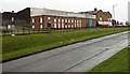
Renfrewshire Electronics
On Port Glasgow Industrial Estate. Viewed across Dubbs Road from Gryfe Road.
Image: © Thomas Nugent
Taken: 13 Dec 2013
0.02 miles
2
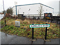
Gareloch Road
Off Dubbs Road at Port Glasgow Industrial Estate.
Image: © Thomas Nugent
Taken: 13 Dec 2013
0.05 miles
3
Gryfe Road
The turning point at the end of the road. Dubbs Road is down a steep embankment on the right.
Image: © Thomas Nugent
Taken: 13 Dec 2013
0.05 miles
4
Crosshill Road
This part of Crosshill Road still has a country lane feel about it.
Image: © Thomas Nugent
Taken: 13 Dec 2013
0.06 miles
5
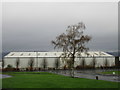
Industrial building and silver birch, Mid Auchinleck
Image: © Jonathan Thacker
Taken: 31 Oct 2017
0.07 miles
6
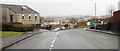
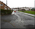
Muirdykes Avenue
In Devol housing scheme, with Knockmountain Hill just visible on the horizon.
Image: © Thomas Nugent
Taken: 13 Dec 2013
0.08 miles
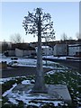
7
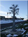
National Cycle Network route marker
The 22 mile marker on Route 75 at Crosshill, Port Glasgow. Dubbs Road and part of Port Glasgow Industrial Estate are visible in the background.
The Tree of Life sculpture is by Jackie Marshall.
Image: © Thomas Nugent
Taken: 11 Feb 2009
0.09 miles
8
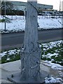
National Cycle Network route marker
Detail view of the "Tree of Life" sculpture by Jackie Marshall, showing a woodpecker and number 22 in what appears to be curly telephone style cable.
Image: © Thomas Nugent
Taken: 11 Feb 2009
0.09 miles
9
National Cycle Network route marker
The 22 mile marker at Crosshill, Port Glasgow. Dubbs Road and Morar Road are visible in the background.
The Tree of Life sculpture is by Jackie Marshall.
Image: © Thomas Nugent
Taken: 11 Feb 2009
0.10 miles
10
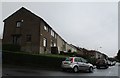
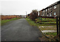
Merrylee Avenue
Former local authority housing.
Image: © Jonathan Thacker
Taken: 31 Oct 2017
0.10 miles