IMAGES TAKEN NEAR TO
Wallace Street, PORT GLASGOW, PA14 5RB
Introduction
This page details the photographs taken nearby to Wallace Street, PA14 5RB by members of the Geograph project.
The Geograph project started in 2005 with the aim of publishing, organising and preserving representative images for every square kilometre of Great Britain, Ireland and the Isle of Man.

There are currently over 7.5m images from over14,400 individuals and you can help contribute to the project by visiting https://www.geograph.org.uk
Image Map (Loading...)


Getting Data...Please wait
Leaflet Map data © OpenStreetMap
Images are licensed for reuse under creativecommons.org/licenses/by-sa/2.0
Notes
- Clicking on the map will re-center to the selected point.
- The higher the marker number, the further away the image location is from the centre of the postcode.
Image Listing (459 Images Found)
Images are licensed for reuse under creativecommons.org/licenses/by-sa/2.0
Image
Details
Distance
1
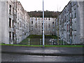
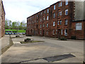
Clune Park Street
The rear of the flats between Clune Park Street, Glasgow Road and Wallace Street. This once desirable part of the east end of Port Glasgow has become run down in recent years.
Image: © Thomas Nugent
Taken: 18 Mar 2011
0.02 miles
2
Clune Park Street
Viewed from Robert Street.
Image: © Thomas Nugent
Taken: 17 Apr 2017
0.02 miles
3
Clune Park Street
Viewed from Robert Street.
Image: © Thomas Nugent
Taken: 17 Apr 2017
0.02 miles
4
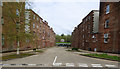
Wallace Street
Viewed from Robert Street.
Image: © Thomas Nugent
Taken: 17 Apr 2017
0.03 miles
5
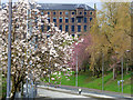
Glasgow Road
The former A8 in the east end of Port Glasgow is still a dual carriageway, the cyclist in the outside lane indicates how quiet the road is. The former Gourock Ropeworks mill building can be seen in the distance.
Image: © Thomas Nugent
Taken: 17 Apr 2017
0.03 miles
6
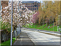
Glasgow Road
The former A8 in the east end of Port Glasgow is still a dual carriageway, the cyclist riding west on the east bound carriageway indicates how quiet the road is. The former Gourock Ropeworks mill building can be seen in the distance.
Image: © Thomas Nugent
Taken: 17 Apr 2017
0.03 miles
7
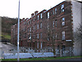
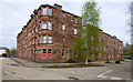
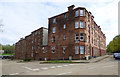
Clune Park Street
Run down flats in a once desirable part of the east end of Port Glasgow.
Image: © Thomas Nugent
Taken: 18 Mar 2011
0.03 miles
8
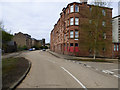
Robert Street
Clune Park Street is on the right.
Image: © Thomas Nugent
Taken: 17 Apr 2017
0.04 miles
9
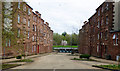
Bruce Street
Looking towards Glasgow Road and the railway line.
Image: © Thomas Nugent
Taken: 17 Apr 2017
0.05 miles
10
Clune Park Street
This was the site of Clune Park football ground (1881-1917), which was home to Port Glasgow Athleitic FC and later Port Glasgow Athletic Juniors FC https://en.wikipedia.org/wiki/Clune_Park .
Robert Street is to the right.
Image: © Thomas Nugent
Taken: 17 Apr 2017
0.05 miles