IMAGES TAKEN NEAR TO
Newark Street, PORT GLASGOW, PA14 5PE
Introduction
This page details the photographs taken nearby to Newark Street, PA14 5PE by members of the Geograph project.
The Geograph project started in 2005 with the aim of publishing, organising and preserving representative images for every square kilometre of Great Britain, Ireland and the Isle of Man.

There are currently over 7.5m images from over14,400 individuals and you can help contribute to the project by visiting https://www.geograph.org.uk
Image Map
Images are licensed for reuse under creativecommons.org/licenses/by-sa/2.0
Notes
- Clicking on the map will re-center to the selected point.
- The higher the marker number, the further away the image location is from the centre of the postcode.
Image Listing (837 Images Found)
Images are licensed for reuse under creativecommons.org/licenses/by-sa/2.0
Image
Details
Distance
1
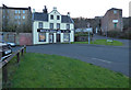
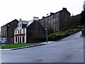
Reflections, Newark Street
The well maintained building is on Newark Street, dates from 1770 and is Caegory B Listed http://portal.historicenvironment.scot/designation/LB40077 .
Image: © Thomas Nugent
Taken: 8 Jan 2019
0.00 miles
2
Reflections
The well maintained building is on Newark Street, dates from 1770 and is Caegory B Listed http://portal.historicenvironment.scot/designation/LB40077 .
Image: © Thomas Nugent
Taken: 8 Jan 2019
0.00 miles
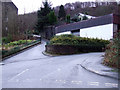
3
Newark Street
Between Clune Brae and Bouverie Street.
Image: © Thomas Nugent
Taken: 27 Jan 2013
0.00 miles
4
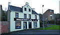
Newark Street
Number 14 to 16 Nweark Street, with Kilmory Terrace behind.
Image: © Thomas Nugent
Taken: 8 Jan 2019
0.00 miles
5
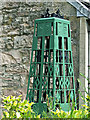
Sculpture at Newark Street
I am not sure what this represents - it appears to have a religious theme. At the corner of Newark Street and Lower Bouverie Street.
Image: © Thomas Nugent
Taken: 28 Jun 2014
0.01 miles
6
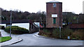
Newark Street
Viewed across the A761 Clune Brae.
Image: © Thomas Nugent
Taken: 8 Apr 2016
0.01 miles
7
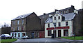
Lower Bouverie Street
Looking towards the shops on Newark Street and the Kilmory Terrace tenement.
Image: © Thomas Nugent
Taken: 27 Jan 2013
0.02 miles
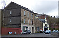
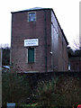
8
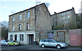
Lower Bouverie Street
The red brick building is a survivor from the former Gourock Ropeworks mill complex. The remains of another similar building can be seen to its right.
Image: © Thomas Nugent
Taken: 27 Jan 2013
0.02 miles
9
Newark Place and Lower Bouverie Street
Newark Place is the narrow lane on the left.
Image: © Thomas Nugent
Taken: 27 Jan 2013
0.02 miles
10
Old mill building
A small part of the former Gourock Ropeworks mill complex. The remains of a similar building can be seen to the right.
Image: © Thomas Nugent
Taken: 27 Jan 2013
0.03 miles