IMAGES TAKEN NEAR TO
Kelburne Oval, PAISLEY, PA1 3SX
Introduction
This page details the photographs taken nearby to Kelburne Oval, PA1 3SX by members of the Geograph project.
The Geograph project started in 2005 with the aim of publishing, organising and preserving representative images for every square kilometre of Great Britain, Ireland and the Isle of Man.

There are currently over 7.5m images from over14,400 individuals and you can help contribute to the project by visiting https://www.geograph.org.uk
Image Map
Images are licensed for reuse under creativecommons.org/licenses/by-sa/2.0
Notes
- Clicking on the map will re-center to the selected point.
- The higher the marker number, the further away the image location is from the centre of the postcode.
Image Listing (99 Images Found)
Images are licensed for reuse under creativecommons.org/licenses/by-sa/2.0
Image
Details
Distance
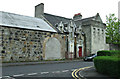
1
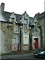
Former Whitehaugh Barracks
A bricked-up archway and door on Whitehaugh Street.
Image: © Thomas Nugent
Taken: 5 May 2014
0.03 miles
2
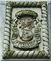
Former Whitehaugh Barracks
A crumbling Royal Engineers insignia and motto above a door on Whitehaugh Avenue. The insignia originally showed an exploding grenade with nine flames https://www.re-museum.co.uk/wp-content/uploads/2015/07/The-Royal-Engineers-Symbols-and-Other-Info.pdf . It appears that the letters RE might have been present in the grenade.
"Ubique - Quo faset Gloria Ducunt" = Everywhere, where Right and Glory Lead.
Image: © Thomas Nugent
Taken: 5 May 2014
0.03 miles
3
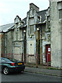
Former Whitehaugh Barracks
A surviving door on the Whitehaugh Avenue side. Others nearby have been bricked-up.
Image: © Thomas Nugent
Taken: 5 May 2014
0.03 miles
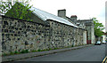
4
Former Whitehaugh Barracks
On Whitehaugh Avenue.
Image: © Thomas Nugent
Taken: 5 May 2014
0.03 miles
5
Former Whitehaugh Barracks
On Whitehaugh Avenue.
Image: © Thomas Nugent
Taken: 5 May 2014
0.03 miles
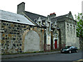
6
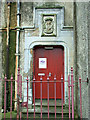
Former Paisley Infantry Barracks
This photo shows the Whitehaugh Avenue side of some of the remaining barracks buildings, viewed from Kelburne Drive. Canmore describes this building as follows, "Despite its 'antique' appearance, as an L-shaped tower house it seems that the hall, which bears an artillery crest, is of the interwar period. The actual hall, to the south of the 1930s building, seems to be an adaptation of a pre-existing building of the barracks".
The red door bears a Renfrewshire Council logo, but there is no indication about the current use (if there is any) of the building.
Image: © Thomas Nugent
Taken: 5 May 2014
0.03 miles
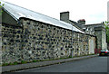
7
Former Paisley Infantry Barracks
This photo shows the Whitehaugh Avenue side of some of the remaining barracks buildings. Canmore describes the building with the chimneys as follows, "Despite its 'antique' appearance, as an L-shaped tower house it seems that the hall, which bears an artillery crest, is of the interwar period. The actual hall, to the south of the 1930s building, seems to be an adaptation of a pre-existing building of the barracks".
Image: © Thomas Nugent
Taken: 5 May 2014
0.03 miles
8
Former Whitehaugh Barracks
On Whitehaugh Avenue.
Image: © Thomas Nugent
Taken: 5 May 2014
0.03 miles
9

Kelburne Oval
The building on the left is part of the former Whitehaugh Barracks complex.
Image: © Thomas Nugent
Taken: 5 May 2014
0.03 miles
10

Former Whitehaugh Barracks
On Whitehaugh Avenue at the corner of Kelburne Oval.
Image: © Thomas Nugent
Taken: 5 May 2014
0.03 miles