IMAGES TAKEN NEAR TO
Horsewood Road, BRIDGE OF WEIR, PA11 3BD
Introduction
This page details the photographs taken nearby to Horsewood Road, PA11 3BD by members of the Geograph project.
The Geograph project started in 2005 with the aim of publishing, organising and preserving representative images for every square kilometre of Great Britain, Ireland and the Isle of Man.

There are currently over 7.5m images from over14,400 individuals and you can help contribute to the project by visiting https://www.geograph.org.uk
Image Map
Images are licensed for reuse under creativecommons.org/licenses/by-sa/2.0
Notes
- Clicking on the map will re-center to the selected point.
- The higher the marker number, the further away the image location is from the centre of the postcode.
Image Listing (89 Images Found)
Images are licensed for reuse under creativecommons.org/licenses/by-sa/2.0
Image
Details
Distance
1
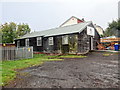
Home of the 1st Bridge of Weir Scout Group
Still standing. Previously housed the 28th Renfrewshire Scouts and Cubs.
Image: © Ian Paterson
Taken: 26 Sep 2018
0.01 miles
2
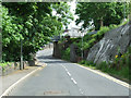
Torr Road
Looking down the hill towards the former Princes Pier railway line.
Image: © Thomas Nugent
Taken: 14 Jun 2013
0.03 miles
3
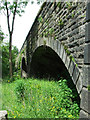
Bridge of Weir Viaduct
Looking towards the single plate-girder approach span over the A761. Originally it was double width right across. It was built by the Greenock and Ayrshire Railway and opened in 1869. The railway line now forms part of National Cycle Route 75. The viaduct is Category B listed http://portal.historicenvironment.scot/designation/LB12688.
Image: © Richard Sutcliffe
Taken: 25 Mar 2022
0.04 miles
4
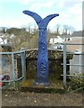
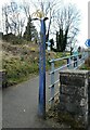
National Cycle Route Millennium Milepost
The Fossil Tree (John Mills) Milepost at the end of the Bridge of Weir Viaduct on National Cycle Route 75.
Image: © Richard Sutcliffe
Taken: 25 Mar 2022
0.04 miles
5
Bridge of Weir railway viaduct
Carrying the former Glasgow to Princes Pier line high above the River Gryfe. A Category B Listed building http://data.historic-scotland.gov.uk/pls/htmldb/f?p=2200:15:0::::BUILDING:12688 . Now part of National Cycle Network Route 75.
Image: © Thomas Nugent
Taken: 14 Jun 2013
0.04 miles
6
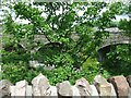
Bridge of Weir railway viaduct
Carrying the former Glasgow to Princes Pier line high above the River Gryfe. A Category B Listed building http://data.historic-scotland.gov.uk/pls/htmldb/f?p=2200:15:0::::BUILDING:12688 . Unfortunately obscured by greenery on the Torr Road side.
Image: © Thomas Nugent
Taken: 14 Jun 2013
0.04 miles
7
Bridge of Weir railway viaduct
Carrying the former Glasgow to Princes Pier line high above the River Gryfe. A Category B Listed building http://data.historic-scotland.gov.uk/pls/htmldb/f?p=2200:15:0::::BUILDING:12688 . Unfortunately obscured by greenery on the Torr Road side.
Image: © Thomas Nugent
Taken: 14 Jun 2013
0.04 miles
8
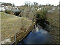
River Gryfe
Seen from the Bridge of Weir Viaduct.
Image: © Richard Sutcliffe
Taken: 25 Mar 2022
0.04 miles
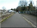
9
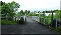
Access on to National Cycle Route 75
The path joins National Cycle Route 75, which follows the old railway line.
Image: © Richard Sutcliffe
Taken: 25 Mar 2022
0.05 miles
10
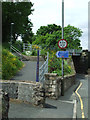
National Cycle Network Route 75
The access point at Torr Road.
Image: © Thomas Nugent
Taken: 14 Jun 2013
0.05 miles