IMAGES TAKEN NEAR TO
Rycote Lane, THAME, OX9 2NY
Introduction
This page details the photographs taken nearby to Rycote Lane, OX9 2NY by members of the Geograph project.
The Geograph project started in 2005 with the aim of publishing, organising and preserving representative images for every square kilometre of Great Britain, Ireland and the Isle of Man.

There are currently over 7.5m images from over14,400 individuals and you can help contribute to the project by visiting https://www.geograph.org.uk
Image Map
Images are licensed for reuse under creativecommons.org/licenses/by-sa/2.0
Notes
- Clicking on the map will re-center to the selected point.
- The higher the marker number, the further away the image location is from the centre of the postcode.
Image Listing (7 Images Found)
Images are licensed for reuse under creativecommons.org/licenses/by-sa/2.0
Image
Details
Distance
2
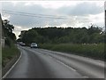
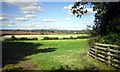
A329 Rycote Lane
Towards Thame from Wallingford.
Image: © Robin Webster
Taken: 22 Mar 2020
0.07 miles
3
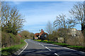
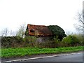
Hole in the Roof
Rustic old building going to ruin beside the A329.
Image: © Des Blenkinsopp
Taken: 6 Oct 2012
0.12 miles
4
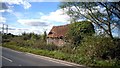
A329 at the northern entry to Milton Common industrial estate
Image: © Peter Whatley
Taken: 19 Jun 2012
0.16 miles
7
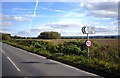
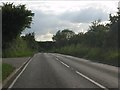
The Camp Industrial Estate
If you're serious minded and Politically Correct, then this is just a road sign on the A329.
On the other hand......
Image: © Des Blenkinsopp
Taken: 6 Oct 2012
0.24 miles