IMAGES TAKEN NEAR TO
Old Union Way, THAME, OX9 2DF
Introduction
This page details the photographs taken nearby to Old Union Way, OX9 2DF by members of the Geograph project.
The Geograph project started in 2005 with the aim of publishing, organising and preserving representative images for every square kilometre of Great Britain, Ireland and the Isle of Man.

There are currently over 7.5m images from over14,400 individuals and you can help contribute to the project by visiting https://www.geograph.org.uk
Image Map
Images are licensed for reuse under creativecommons.org/licenses/by-sa/2.0
Notes
- Clicking on the map will re-center to the selected point.
- The higher the marker number, the further away the image location is from the centre of the postcode.
Image Listing (243 Images Found)
Images are licensed for reuse under creativecommons.org/licenses/by-sa/2.0
Image
Details
Distance
1
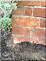
Benchmark on #22 Michaelis Road
Ordnance Survey cut mark benchmark described on the Bench Mark Database at http://www.bench-marks.org.uk/bm35893
Image: © Roger Templeman
Taken: 3 Nov 2010
0.05 miles
2
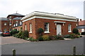
#22 Michaelis Road
This former building of Rycotewood College has an OS benchmark Image on the front left corner
Image: © Roger Templeman
Taken: 8 Oct 2013
0.05 miles
3

Stone steps, St. Mary's, Thame
These stone steps into the churchyard of St.Mary's church in Thame are opposite the Prebendal. They make an unusual alternative to a gateway !
Image: © Rob Farrow
Taken: 29 Apr 2006
0.07 miles
4
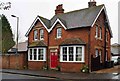
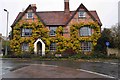
The former Plough (1), Priestend, Thame, Oxon
The Beerhouse Act of 1830 abolished beer tax and allowed the opening of beerhouses which were restricted to selling beer. The Government's aim was to discourage working people from drinking gin. So popular was the new act that thousands of beer houses opened within months of its passing. One of these was The Plough which opened here in that year. Many later went on to become full public houses able to sell a much wider range of drinks. Whether this one did is not known. It closed as long ago as 1917 and is now a private house. When it was open it was for most of its life a Morrells (of Oxford) house, but from 1911 to its closure it was owned by Halls.
Image
Image: © P L Chadwick
Taken: 18 Nov 2017
0.08 miles
5
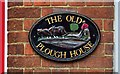
The former Plough (2) - sign, Priestend, Thame, Oxon
This modern sign is on the wall by the entrance door. This used to be a beerhouse called The Plough but it closed in 1917. It is now a private house.
Image
Image: © P L Chadwick
Taken: 18 Nov 2017
0.08 miles
7
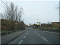
Priestend seen from Oxford Road, Thame, Oxon
Oxford Road seems to become Priestend by the nearest lamppost. At the other end of Priestend a sharp right turn leads into High Street, which is the start of the main shopping and business district.
Image: © P L Chadwick
Taken: 18 Nov 2017
0.09 miles
8

Cuttle Brook
A small tributary of the River Thame.
Image: © Bill Boaden
Taken: 21 Apr 2018
0.09 miles
9
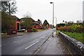
Old house, Priestend, Thame, Oxon
An attractive house in Priestend.
Image: © P L Chadwick
Taken: 18 Nov 2017
0.09 miles
10
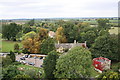
View west from top of St Mary's Church tower
Image: © Roger Templeman
Taken: 8 Oct 2013
0.10 miles