IMAGES TAKEN NEAR TO
OX9 1HY
Introduction
This page details the photographs taken nearby to OX9 1HY by members of the Geograph project.
The Geograph project started in 2005 with the aim of publishing, organising and preserving representative images for every square kilometre of Great Britain, Ireland and the Isle of Man.

There are currently over 7.5m images from over14,400 individuals and you can help contribute to the project by visiting https://www.geograph.org.uk
Image Map
Images are licensed for reuse under creativecommons.org/licenses/by-sa/2.0
Notes
- Clicking on the map will re-center to the selected point.
- The higher the marker number, the further away the image location is from the centre of the postcode.
Image Listing (10 Images Found)
Images are licensed for reuse under creativecommons.org/licenses/by-sa/2.0
Image
Details
Distance
1
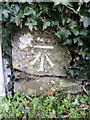
Benchmark on wall at entrance to Earlywood Paddock, Ladder Hill
Ordnance Survey cut mark benchmark described on the Bench Mark Database at http://www.bench-marks.org.uk/bm36509
Image: © Roger Templeman
Taken: 24 Jan 2011
0.03 miles
2
View across Ladder Hill of Earlywood Paddock entrance
There is an OS benchmark Image on the near end of the ivy-clad wall at its junction with the white fence
Image: © Roger Templeman
Taken: 1 Nov 2013
0.03 miles
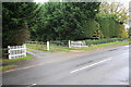
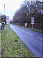
3
Ladder Hill, Wheatley
There are a succession of chicanes, all to the advantage of uphill traffic leaving the village centre.
Image: © Robin Webster
Taken: 25 Apr 2021
0.12 miles
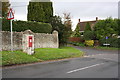
4
Benchmarked letter box on west side of Ladder Hill
The Ordnance Survey cut mark benchmark is described on the Bench Mark Database at http://www.bench-marks.org.uk/bm36554
Image: © Roger Templeman
Taken: 24 Jan 2011
0.13 miles
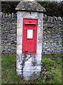
5
Junction of Ladder Hill and Windmill Lane
There is an OS benchmark Image on the front of the pillar box
Image: © Roger Templeman
Taken: 1 Nov 2013
0.13 miles
6
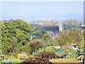
Howe Allotments, Windmill Lane, Wheatley
Howe Allotments, Windmill Lane, Wheatley with St. Mary's church in the distance.
Image: © Mike Harris
Taken: 14 Oct 2007
0.16 miles
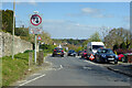
7
Traffic calming signs at entrance to village on Ladder Hill
Image: © Roger Templeman
Taken: 24 Jan 2011
0.18 miles
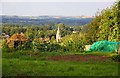
9
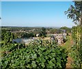
A View With Vegetables
The Howe allotments are on a steepish hillside above Wheatley giving this wide view over the town and the Thame valley beyond.
Image: © Des Blenkinsopp
Taken: 5 Sep 2012
0.24 miles
10
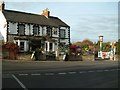
The Railway, Wheatley
The railway has now gone, but the pub is a reminder of the railway line which once ran through Wheatley. Note the Signal, and crossing gate at the entrance to the Car Park.
Image: © Colin Bates
Taken: 13 Dec 2005
0.24 miles