IMAGES TAKEN NEAR TO
OX8 6EG
Introduction
This page details the photographs taken nearby to OX8 6EG by members of the Geograph project.
The Geograph project started in 2005 with the aim of publishing, organising and preserving representative images for every square kilometre of Great Britain, Ireland and the Isle of Man.

There are currently over 7.5m images from over14,400 individuals and you can help contribute to the project by visiting https://www.geograph.org.uk
Image Map
Images are licensed for reuse under creativecommons.org/licenses/by-sa/2.0
Notes
- Clicking on the map will re-center to the selected point.
- The higher the marker number, the further away the image location is from the centre of the postcode.
Image Listing (60 Images Found)
Images are licensed for reuse under creativecommons.org/licenses/by-sa/2.0
Image
Details
Distance
1
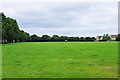
King George's Field, Newland, Witney, Oxon
Looking from near the main entrance. The houses adjacent to the field, in the far distance, are in Kingsfield Crescent.
Image
Image
Image: © P L Chadwick
Taken: 19 Jun 2016
0.10 miles
2
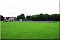
Basketball Court (1), King George's Field, Newland, Witney, Oxon
The houses in the distance are in Pensclose.
Image
Image: © P L Chadwick
Taken: 19 Jun 2016
0.10 miles
3
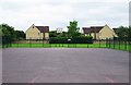
Basketball Court (2), King George's Field, Newland, Witney, Oxon
The houses adjacent to King George's Field are in Kingsfield Crescent.
Image
Image: © P L Chadwick
Taken: 19 Jun 2016
0.11 miles
4
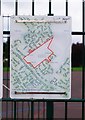
Map at St. George's Field, Newland, Witney, Oxon
This map shows the field and is attached to the fencing of the basketball court.
Image: © P L Chadwick
Taken: 19 Jun 2016
0.11 miles
5
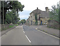
B4022 Newland junction with Newland Mill
Image: © Stuart Logan
Taken: 15 Jul 2012
0.12 miles
6
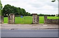
Main entrance to King George's Field, Newland, Witney, Oxon
The gateposts each have a heraldic emblem. The field is managed by Witney Town Council. The overall responsibility for the field rests in the National Playing Fields Association, who now use the operating name of Fields in Trust. This part of Newland is sometimes known as Oxford Hill.
Image
Image
Image: © P L Chadwick
Taken: 19 Jun 2016
0.12 miles
7
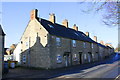
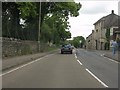
Row of houses on SW side of Newland
There is an OS benchmark Imageon the near corner, road face, of the nearest house
Image: © Roger Templeman
Taken: 7 Feb 2017
0.12 miles
8
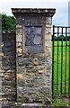
Heraldic emblem, King George's Field, Newland, Witney, Oxon
This heraldic emblem is on the lefthand gatepost of the main entrance to the field. It shows a lion holding a shield with the words George V and underneath A.D. 1910 -1936. These were the dates of his reign.
The heraldic emblem on the righthand gatepost is shown here:- Image
Image
Image: © P L Chadwick
Taken: 19 Jun 2016
0.12 miles
9
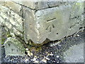
Benchmark on #90 Newland
Ordnance Survey cut mark benchmark described on the Bench Mark Database at http://www.bench-marks.org.uk/bm37173
Image: © Roger Templeman
Taken: 1 Mar 2011
0.12 miles