IMAGES TAKEN NEAR TO
CHIPPING NORTON, OX7 9DF
Introduction
This page details the photographs taken nearby to OX7 9DF by members of the Geograph project.
The Geograph project started in 2005 with the aim of publishing, organising and preserving representative images for every square kilometre of Great Britain, Ireland and the Isle of Man.

There are currently over 7.5m images from over14,400 individuals and you can help contribute to the project by visiting https://www.geograph.org.uk
Image Map
Images are licensed for reuse under creativecommons.org/licenses/by-sa/2.0
Notes
- Clicking on the map will re-center to the selected point.
- The higher the marker number, the further away the image location is from the centre of the postcode.
Image Listing (75 Images Found)
Images are licensed for reuse under creativecommons.org/licenses/by-sa/2.0
Image
Details
Distance
1
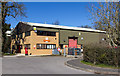
Royal Mail Delivery Office, Chipping Norton
The Royal Mail depot in Station Road.
Image: © David P Howard
Taken: 16 Mar 2014
0.01 miles
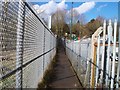
2

Footpath towards town centre
A footpath across a corner of the common, from Station Road to New Street.
Image: © David P Howard
Taken: 16 Mar 2014
0.05 miles
3

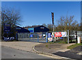
Station Yard Industrial Estate
The estate has been built on the site of Chipping Norton railway station and goods yard. A public footpath to Chipping Norton Common runs down the side of the nearest building.
Image: © Michael Dibb
Taken: 20 Feb 2010
0.05 miles
4

Cotswold Tool and Plant Hire, Chipping Norton
A plant hire company on Station Road.
Image: © David P Howard
Taken: 16 Mar 2014
0.05 miles
5

The old feed warehouse
This was built as an animal feed warehouse. At the time of building, there were thousands of horses working the land in the area and Chipping Norton railway station was literally across the road. The building was refurbished and used as a jewellery manufacturing company. Now empty and boarded-up.
Image: © Michael Dibb
Taken: 20 Feb 2010
0.06 miles
6
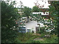
Footpath to the common
The path passes between two plots of the Station Yard Industrial Estate. The through railway line ran just in front of the camera. The line was the Banbury to Cheltenham Direct, closed and dismantled in the 1960s.
Image: © Michael Dibb
Taken: 20 Feb 2010
0.06 miles
7
Chipping Norton railway station (site),
Opened in 1855 as a terminus, and then rebuilt in 1887 as a through station by the Banbury & Cheltenham Direct Railway, this station closed to passengers in 1962 and completely in 1964.
View south towards Sarsden Halt and Cheltenham. The station site is now an industrial estate surrounded by a lot of new vegetation!
Image: © Nigel Thompson
Taken: 26 Jul 2009
0.06 miles
8

Footpath towards town centre
A footpath across a corner of the common, from Station Road to New Street.
Image: © David P Howard
Taken: 16 Mar 2014
0.06 miles
9
Jewson, Chipping Norton
Builders Merchants on Station Road.
Image: © David P Howard
Taken: 16 Mar 2014
0.07 miles
10

Station Mill, Chipping Norton
Along Station Road, a modern building with a name rooted in the past. There was an old railway line along here years ago, and also a large mill, now converted to housing.
Image: © Des Blenkinsopp
Taken: 25 Feb 2019
0.08 miles