IMAGES TAKEN NEAR TO
The Leys, CHIPPING NORTON, OX7 6QH
Introduction
This page details the photographs taken nearby to The Leys, OX7 6QH by members of the Geograph project.
The Geograph project started in 2005 with the aim of publishing, organising and preserving representative images for every square kilometre of Great Britain, Ireland and the Isle of Man.

There are currently over 7.5m images from over14,400 individuals and you can help contribute to the project by visiting https://www.geograph.org.uk
Image Map (Loading...)


Getting Data...Please wait
Leaflet Map data © OpenStreetMap
Images are licensed for reuse under creativecommons.org/licenses/by-sa/2.0
Notes
- Clicking on the map will re-center to the selected point.
- The higher the marker number, the further away the image location is from the centre of the postcode.
Image Listing (15 Images Found)
Images are licensed for reuse under creativecommons.org/licenses/by-sa/2.0
Image
Details
Distance
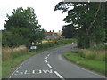
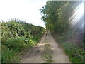
1
Start of bridleway
The bridleway starts on the opposite side of the minor road from High Street. Initially the way is a surfaced lane which serves as access for the house to the right named The Leys.
Image: © Michael Dibb
Taken: 11 Sep 2011
0.02 miles
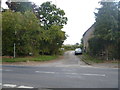
3
Bridleway on track
Seen on a very sunny day, the surfaced lane soon deteriorates to a track. The bridleway is now part of the recently designated D'Arcy Dalton Way.
Image: © Michael Dibb
Taken: 11 Sep 2011
0.03 miles
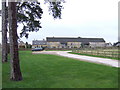
4
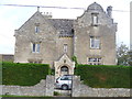
Lyneham Farm
This magnificent farmhouse is dated 1843 and, along with the attached farm buildings is listed grade II. Further details are at http://www.britishlistedbuildings.co.uk/en-254064-lyneham-farmhouse-and-attached-farmbuild
Image: © Michael Dibb
Taken: 11 Sep 2011
0.04 miles
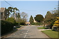
5
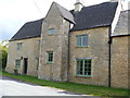
Isods Farmhouse
This wonderful grade II listed farmhouse and attached barns is on the south side of High Street, Lyneham. Further details at http://www.britishlistedbuildings.co.uk/en-254066-isods-farmhouse-and-attached-barn-lyneha
Image: © Michael Dibb
Taken: 11 Sep 2011
0.06 miles
6
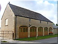
Cart shed
Alongside the High Street in the village this former cart shed has been converted to residential usage. It is a listed building, grade II. More details at http://www.britishlistedbuildings.co.uk/en-254067-cart-shelter-approximately-10-metre-west
Image: © Michael Dibb
Taken: 11 Sep 2011
0.08 miles
7
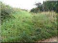
Start of footpath
A footpath branches off this bridleway and runs to Merriscourt Farm where it meets another bridleway.
Image: © Michael Dibb
Taken: 11 Sep 2011
0.09 miles