IMAGES TAKEN NEAR TO
Eversley Lane, CHIPPING NORTON, OX7 6PQ
Introduction
This page details the photographs taken nearby to Eversley Lane, OX7 6PQ by members of the Geograph project.
The Geograph project started in 2005 with the aim of publishing, organising and preserving representative images for every square kilometre of Great Britain, Ireland and the Isle of Man.

There are currently over 7.5m images from over14,400 individuals and you can help contribute to the project by visiting https://www.geograph.org.uk
Image Map (Loading...)


Getting Data...Please wait
Leaflet Map data © OpenStreetMap
Images are licensed for reuse under creativecommons.org/licenses/by-sa/2.0
Notes
- Clicking on the map will re-center to the selected point.
- The higher the marker number, the further away the image location is from the centre of the postcode.
Image Listing (50 Images Found)
Images are licensed for reuse under creativecommons.org/licenses/by-sa/2.0
Image
Details
Distance
1
![Footpath to Kingham [1]](https://s1.geograph.org.uk/geophotos/01/86/36/1863669_0338a0e6_120x120.jpg)
Footpath to Kingham [1]
The footpath leaves the B4055 road and initially passes along this narrow track through the village.
Image: © Michael Dibb
Taken: 30 Apr 2010
0.04 miles
2
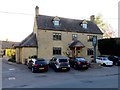
The Chequers, Churchill
The Chequers is built in the tradition mellow Cotswold stone and stands on the main road passing through the village of Churchill.
Image: © Philip Halling
Taken: 7 Jun 2017
0.06 miles
3
![Footpath to Kingham [2]](https://s2.geograph.org.uk/geophotos/01/86/36/1863670_842a5c9f_120x120.jpg)
Footpath to Kingham [2]
The footpath leaves the village and passes through open fields.
Image: © Michael Dibb
Taken: 30 Apr 2010
0.06 miles
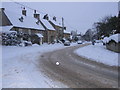
6
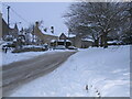
Chequers Inn, Church Road, Churchill in snow
Image: © Nick Barber
Taken: 21 Dec 2010
0.07 miles
7
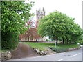
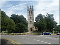
Start of footpath
This short footpath across the village green cuts out a bend in the B4055 road. All Saints church in the background.
Image: © Michael Dibb
Taken: 30 Apr 2010
0.09 miles
8
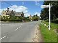
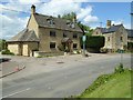
Road junction in Churchill
Road junction in the village of Churchill with a sign indicating it is just 2 miles to the railway station of Kingham.
Image: © Philip Halling
Taken: 7 Jun 2017
0.10 miles
10
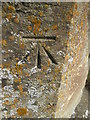
Ordnance Survey Cut Mark
This OS cut mark can be found on the west angle of All Saints Church. It marks a point 165.6334m above mean sea level.
Image: © Adrian Dust
Taken: 27 Jun 2015
0.10 miles