IMAGES TAKEN NEAR TO
Sinnels Field, CHIPPING NORTON, OX7 6EJ
Introduction
This page details the photographs taken nearby to Sinnels Field, OX7 6EJ by members of the Geograph project.
The Geograph project started in 2005 with the aim of publishing, organising and preserving representative images for every square kilometre of Great Britain, Ireland and the Isle of Man.

There are currently over 7.5m images from over14,400 individuals and you can help contribute to the project by visiting https://www.geograph.org.uk
Image Map
Images are licensed for reuse under creativecommons.org/licenses/by-sa/2.0
Notes
- Clicking on the map will re-center to the selected point.
- The higher the marker number, the further away the image location is from the centre of the postcode.
Image Listing (39 Images Found)
Images are licensed for reuse under creativecommons.org/licenses/by-sa/2.0
Image
Details
Distance
1
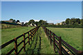
Footpath to Shipton under Wychwood
The route of this path has been fenced off on both sides, perhaps to minimise contact with the horses which sometimes occupy the field.
Image: © Bill Boaden
Taken: 7 Aug 2020
0.11 miles
2
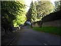
Mawles Lane, Shipton Under Wychwood
Narrow one way lane running from the high street (A361) to the 'Fiveways' crossroads.
Image: © andrew auger
Taken: 4 Oct 2010
0.11 miles
3
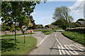
"Fiveways", Shipton Under Wychwood
The meeting of 5 roads near the South Eastern edge of the village.
Image: © andrew auger
Taken: 16 May 2009
0.12 miles
4
Road junction on the outskirts of Shipton-under-Wychwood
Image: © Sarah Charlesworth
Taken: 22 Jul 2010
0.13 miles
5
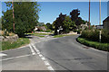
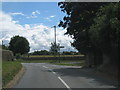
Multiple road junction at Shipton under Wychwood
Five roads converge on this junction. Coldstone Farm is on the right, marking the edge of the village.
Image: © Bill Boaden
Taken: 7 Aug 2020
0.13 miles
6
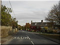
A361 through Shipton Under Wychwood
This is roughly the centre of the village. The road off to the right is to Ascott Under Wychwood, and Leafield.
Image: © andrew auger
Taken: 29 Oct 2009
0.17 miles

8
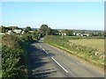
Leafield Road
The approach to Shipton under Wychwood along Leafield Road. Coldstone farm is to the left of the road.
Image: © Jennifer Luther Thomas
Taken: 4 Nov 2006
0.18 miles
9
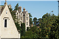
Shipton Court
A rear view of this Grade II* listed building which dates from 1603.
Image: © Bill Boaden
Taken: 7 Aug 2020
0.18 miles
10

Shipton Court at Shipton Under Wychwood
A fine Grade II* listed country house built around 1603. More details here: http://www.imagesofengland.org.uk/Details/Default.aspx?id=251778&mode=adv
Image: © Rod Allday
Taken: 1 Nov 2008
0.19 miles