IMAGES TAKEN NEAR TO
West End, CHIPPING NORTON, OX7 5HA
Introduction
This page details the photographs taken nearby to West End, OX7 5HA by members of the Geograph project.
The Geograph project started in 2005 with the aim of publishing, organising and preserving representative images for every square kilometre of Great Britain, Ireland and the Isle of Man.

There are currently over 7.5m images from over14,400 individuals and you can help contribute to the project by visiting https://www.geograph.org.uk
Image Map
Images are licensed for reuse under creativecommons.org/licenses/by-sa/2.0
Notes
- Clicking on the map will re-center to the selected point.
- The higher the marker number, the further away the image location is from the centre of the postcode.
Image Listing (95 Images Found)
Images are licensed for reuse under creativecommons.org/licenses/by-sa/2.0
Image
Details
Distance
1
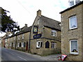
The Bell Inn, Chipping Norton
Good games pub with guest beers
Image: © al partington
Taken: 13 Mar 2006
0.02 miles
2
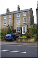
#24 West End
There is an OS benchmark Image on the right hand side, front corner, of the house in the middle of the image,
Image: © Roger Templeman
Taken: 28 Nov 2014
0.02 miles
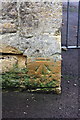
3
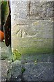
Benchmark on #24 West End
Ordnance Survey cut mark benchmark described on the Bench Mark Database at http://www.bench-marks.org.uk/bm62612
Image: © Roger Templeman
Taken: 24 Nov 2014
0.02 miles
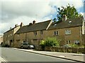
4
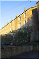
Houses on West End
There is an OS benchmark Image on the side of the near house, at its front corner, above the dry stone wall
Image: © Roger Templeman
Taken: 24 Nov 2014
0.02 miles
5
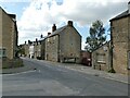
West End, Chipping Norton
The start of the road to Kingham.
Image: © Stephen Craven
Taken: 20 Sep 2021
0.05 miles
6
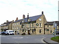
Kings Arms Hotel, Chipping Norton
An Arkells outpost
Image: © al partington
Taken: 13 Mar 2006
0.07 miles
7
Benchmark on St Mary's Primary School, The Green
Ordnance Survey cut mark benchmark described on the Bench Mark Database at http://www.bench-marks.org.uk/bm62614
Image: © Roger Templeman
Taken: 28 Nov 2014
0.08 miles
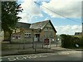
8
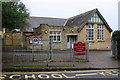
St Mary's C of E (Aided) Primary School
There is an OS benchmark Image on the front of the school at the right hand corner
Image: © Roger Templeman
Taken: 28 Nov 2014
0.08 miles
9
St Mary's C of E Primary School, The Green, Chipping Norton
A Church of England school; the gabled building facing the road appears from early 20th century maps to be the original school building, but it has expanded over the years with the town (the population has grown from less than 4000 in 1910 to around 7000 presently, although that it quite modest growth compared to many other country towns).
Image: © Stephen Craven
Taken: 20 Sep 2021
0.08 miles
10
College Place, West Street, Chipping Norton
A former 17th century farmhouse, listed grade II (list entry 1284046).
Image: © Stephen Craven
Taken: 20 Sep 2021
0.09 miles