IMAGES TAKEN NEAR TO
Sheep Street, CHIPPING NORTON, OX7 3RR
Introduction
This page details the photographs taken nearby to Sheep Street, OX7 3RR by members of the Geograph project.
The Geograph project started in 2005 with the aim of publishing, organising and preserving representative images for every square kilometre of Great Britain, Ireland and the Isle of Man.

There are currently over 7.5m images from over14,400 individuals and you can help contribute to the project by visiting https://www.geograph.org.uk
Image Map
Images are licensed for reuse under creativecommons.org/licenses/by-sa/2.0
Notes
- Clicking on the map will re-center to the selected point.
- The higher the marker number, the further away the image location is from the centre of the postcode.
Image Listing (172 Images Found)
Images are licensed for reuse under creativecommons.org/licenses/by-sa/2.0
Image
Details
Distance
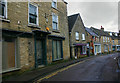
1
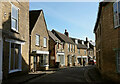
Sheep Street, Charlbury
The building houses Four Shires Kitchen is listed and described at https://historicengland.org.uk/listing/the-list/list-entry/1367841?section=official-listing . The building on the left is also listed https://historicengland.org.uk/listing/the-list/list-entry/1198459?section=official-listing . Sheep Street, the old main route through the town, is followed by the Oxfordshire Way.
Image: © Derek Harper
Taken: 11 Feb 2022
0.01 miles
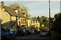
2
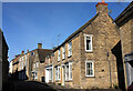
Sheep Street, Charlbury
Approaching the junction with Church Street.
Image: © Derek Harper
Taken: 11 Feb 2022
0.01 miles
4
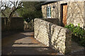
Footpath, Charlbury
Footpath 156 26/10 takes a little chicane, as it were, as it drops from Pooles Lane to Sheep Street.
Image: © Derek Harper
Taken: 11 Feb 2022
0.02 miles
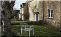
5
Disused premises in Sheep Street, Charlbury
On a wet and wintry day the Chipping Norton limestone from which most of the town is built can give the streets a dismal appearance, especially when properties such as this become take on an abandoned look.
Image: © David Kemp
Taken: 11 Jan 2020
0.02 miles
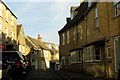
6
Sheep Street in Charlbury
The Olde Three Horseshoes Inn is on the left.
Image: © Steve Daniels
Taken: 28 Apr 2015
0.02 miles
7
Cottages, Charlbury
Beside footpath 156 26/10 that links Pooles Lane to Sheep Street.
Image: © Derek Harper
Taken: 11 Feb 2022
0.03 miles
8
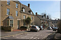
Sheep Street, Charlbury
Second on the left is Hone House https://historicengland.org.uk/listing/the-list/list-entry/1053214?section=official-list-entry . Beyond is Ye Olde Three Horseshoes Inn https://www.geograph.org.uk/search.php?i=176181719 , listed as "The Farmers Public House" https://historicengland.org.uk/listing/the-list/list-entry/1198486?section=official-list-entry . Sheep Street is followed by the Oxfordshire Way.
Image: © Derek Harper
Taken: 11 Feb 2022
0.03 miles
9
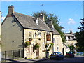
Ye Olde Three Horseshoes Inn
Historic inn of Cotswold stone on Sheep Street, Charlbury.
www.charlbury.info
Image: © Colin Smith
Taken: 21 Aug 2011
0.04 miles
10
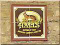
On the Tiles, Charlbury
Old tiles forming a plaque on the wall of Ye Olde Three Horseshoes Inn at Charlbury, now a free house. Halls Oxford & West Brewery limited was based in Oxford but is, sadly, now defunct.
www.charlbury.info
Image: © Colin Smith
Taken: 21 Aug 2011
0.04 miles