IMAGES TAKEN NEAR TO
Spelsbury Road, CHIPPING NORTON, OX7 3LR
Introduction
This page details the photographs taken nearby to Spelsbury Road, OX7 3LR by members of the Geograph project.
The Geograph project started in 2005 with the aim of publishing, organising and preserving representative images for every square kilometre of Great Britain, Ireland and the Isle of Man.

There are currently over 7.5m images from over14,400 individuals and you can help contribute to the project by visiting https://www.geograph.org.uk
Image Map (Loading...)


Getting Data...Please wait
Leaflet Map data © OpenStreetMap
Images are licensed for reuse under creativecommons.org/licenses/by-sa/2.0
Notes
- Clicking on the map will re-center to the selected point.
- The higher the marker number, the further away the image location is from the centre of the postcode.
Image Listing (14 Images Found)
Images are licensed for reuse under creativecommons.org/licenses/by-sa/2.0
Image
Details
Distance
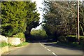
2
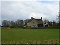
B4026 between Charlbury and Spelsbury
Taken facing north near Bobwell Farm. The western ridge of the Evenlode valley is visible to the left. Image is two miles north on the same road.
Image: © SA Mathieson
Taken: 7 Aug 2005
0.04 miles
7

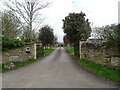
Road to Conygree Farm
The start of quite a long farm driveway.
Image: © Des Blenkinsopp
Taken: 4 Sep 2023
0.16 miles
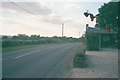
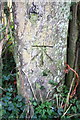
8
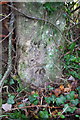
Benchmark on gatepost beside B4026
Ordnance Survey cut mark benchmark described on the Bench Mark Database at http://www.bench-marks.org.uk/bm62269
Image: © Roger Templeman
Taken: 15 Dec 2014
0.18 miles
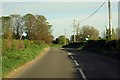
9
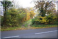
Gateway for track from B4026
There is an OS benchmark Image on a gatepost to the right of the gate
Image: © Roger Templeman
Taken: 18 Nov 2014
0.18 miles
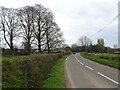
10
Benchmark on wooden gatepost
Ordnance Survey cut mark benchmark described on the Bench Mark Database at http://www.bench-marks.org.uk/bm62157
Image: © Roger Templeman
Taken: 18 Nov 2014
0.22 miles