IMAGES TAKEN NEAR TO
OX6 0RA
Introduction
This page details the photographs taken nearby to OX6 0RA by members of the Geograph project.
The Geograph project started in 2005 with the aim of publishing, organising and preserving representative images for every square kilometre of Great Britain, Ireland and the Isle of Man.

There are currently over 7.5m images from over14,400 individuals and you can help contribute to the project by visiting https://www.geograph.org.uk
Image Map
Images are licensed for reuse under creativecommons.org/licenses/by-sa/2.0
Notes
- Clicking on the map will re-center to the selected point.
- The higher the marker number, the further away the image location is from the centre of the postcode.
Image Listing (7 Images Found)
Images are licensed for reuse under creativecommons.org/licenses/by-sa/2.0
Image
Details
Distance
1
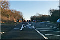
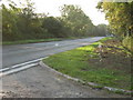
A41 towards Aylesbury
At the B4011 turn.
Image: © Robin Webster
Taken: 28 Dec 2017
0.19 miles
2
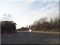
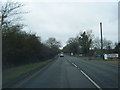
The B4011 at the junction of the A41 east of Bicester
Image: © David Howard
Taken: 20 Mar 2016
0.20 miles
3
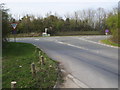
Junction with A41
B4011 junction with the A41
Image: © Shaun Ferguson
Taken: 10 Apr 2010
0.20 miles
4
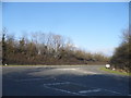
The B4011 at the junction of the A41 east of Bicester
Image: © David Howard
Taken: 20 Mar 2016
0.20 miles
7
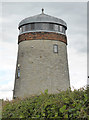
Blackthorn East Mill
Tower windmill converted to a house.
The west mill is shown on the map but is truncated and not visible from a public location.
Image: © Chris Allen
Taken: 9 Aug 2014
0.23 miles