IMAGES TAKEN NEAR TO
OX6 0FH
Introduction
This page details the photographs taken nearby to OX6 0FH by members of the Geograph project.
The Geograph project started in 2005 with the aim of publishing, organising and preserving representative images for every square kilometre of Great Britain, Ireland and the Isle of Man.

There are currently over 7.5m images from over14,400 individuals and you can help contribute to the project by visiting https://www.geograph.org.uk
Image Map
Images are licensed for reuse under creativecommons.org/licenses/by-sa/2.0
Notes
- Clicking on the map will re-center to the selected point.
- The higher the marker number, the further away the image location is from the centre of the postcode.
Image Listing (6 Images Found)
Images are licensed for reuse under creativecommons.org/licenses/by-sa/2.0
Image
Details
Distance
3
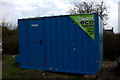
Canteen
The development site at Little Wretchwick farm. All facilities provided.
Image: © Robert Eva
Taken: 23 Mar 2017
0.06 miles
4
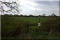
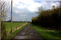
Path to Launton
This leads across fields from Little Wretchwick farm. Very muddy at the time of this visit
Image: © Robert Eva
Taken: 23 Mar 2017
0.07 miles
5
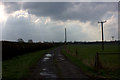
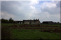
Path to A41
Leading Southwest from Little Wretchwick farm
Image: © Robert Eva
Taken: 23 Mar 2017
0.11 miles