IMAGES TAKEN NEAR TO
Field View Lane, KIDLINGTON, OX5 3FT
Introduction
This page details the photographs taken nearby to Field View Lane, OX5 3FT by members of the Geograph project.
The Geograph project started in 2005 with the aim of publishing, organising and preserving representative images for every square kilometre of Great Britain, Ireland and the Isle of Man.

There are currently over 7.5m images from over14,400 individuals and you can help contribute to the project by visiting https://www.geograph.org.uk
Image Map
Images are licensed for reuse under creativecommons.org/licenses/by-sa/2.0
Notes
- Clicking on the map will re-center to the selected point.
- The higher the marker number, the further away the image location is from the centre of the postcode.
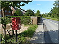
Image Listing (11 Images Found)
Images are licensed for reuse under creativecommons.org/licenses/by-sa/2.0
Image
Details
Distance
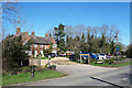
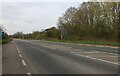
1
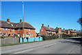
Houses at Bunkers Hill
An isolated development of suburban style housing.
Image: © Des Blenkinsopp
Taken: 5 Apr 2018
0.04 miles
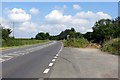
9
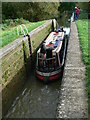
Bakers Lock
One of several locks on the Oxford Canal just south of Gibraltar
Image: © William Wells
Taken: 9 Oct 2005
0.23 miles