IMAGES TAKEN NEAR TO
Canal Close, KIDLINGTON, OX5 3FE
Introduction
This page details the photographs taken nearby to Canal Close, OX5 3FE by members of the Geograph project.
The Geograph project started in 2005 with the aim of publishing, organising and preserving representative images for every square kilometre of Great Britain, Ireland and the Isle of Man.

There are currently over 7.5m images from over14,400 individuals and you can help contribute to the project by visiting https://www.geograph.org.uk
Image Map
Images are licensed for reuse under creativecommons.org/licenses/by-sa/2.0
Notes
- Clicking on the map will re-center to the selected point.
- The higher the marker number, the further away the image location is from the centre of the postcode.
Image Listing (41 Images Found)
Images are licensed for reuse under creativecommons.org/licenses/by-sa/2.0
Image
Details
Distance
3
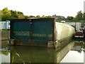
Dry and High
The narrowboat has been moved well above water level for repairs to be carried out. It is a long way from home, being lettered for the Wey Navigation in Surrey.
Image: © Alan Murray-Rust
Taken: 20 Oct 2015
0.05 miles
4
Kingsground Narrowboats
This is the boatbuilding enclosure.
Image: © Alan Murray-Rust
Taken: 20 Oct 2015
0.05 miles
5
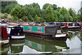
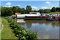
Enslow Marina
Enslow Marina is located on the Oxford Canal between bridges 215 and 216A. It is also home to Kingsground Narrowboats offering the usual boatyard services as well as boat building. The green and red boat in this view has a notice at the front that reads 'A dream is a wish your heart makes'.
Image: © Stephen McKay
Taken: 8 Jul 2020
0.05 miles
6
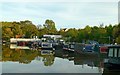
Enslow Marina
Boatbuilding was established here around 1995, the marina being created some 10 years later.
Image: © Alan Murray-Rust
Taken: 20 Oct 2015
0.05 miles
7
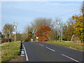
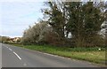
Tall 50 limit signs
There seems no need for such tall signs here, there is no severe hump in the road or anything like that.
Image: © Robin Webster
Taken: 13 Nov 2016
0.06 miles
8
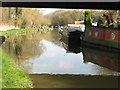
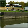
The Oxford Canal at Enslow
Seen from below the railway bridge, visible at the top with reflection below. The fishermen are enjoying a warm, and perhaps soporific afternoon
Image: © David Purchase
Taken: 8 Apr 2015
0.07 miles
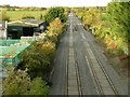
9

Bletchington railway station (site), Oxfordshire
Opened in 1850 by the Great Western Railway on the line from Didcot to Banbury, this station closed in 1964 to passengers and completely in 1965.
View north towards Tackley and Banbury. Nothing appears to survive from 53 years earlier - Image
Image: © Nigel Thompson
Taken: 5 Jun 2014
0.07 miles
10
Site of Bletchington Station
From 1855 to 1892 it was named named Kirtlington, which is slightly nearer than Bletchingdon (or is it Bletchington http://www.bletchingdon-pc.org.uk/ ?), but renamed to avoid confusion with Kidlington which was the next station to the south, and itself renamed at the same time from Woodstock Road after the opening of the branch line to Woodstock. Must have been confusing for the locals. The station closed in 1965, but looked like this http://www.geograph.org.uk/photo/1833402 in 1961.
Image: © Alan Murray-Rust
Taken: 20 Oct 2015
0.07 miles