IMAGES TAKEN NEAR TO
Station Road, KIDLINGTON, OX5 3DE
Introduction
This page details the photographs taken nearby to Station Road, OX5 3DE by members of the Geograph project.
The Geograph project started in 2005 with the aim of publishing, organising and preserving representative images for every square kilometre of Great Britain, Ireland and the Isle of Man.

There are currently over 7.5m images from over14,400 individuals and you can help contribute to the project by visiting https://www.geograph.org.uk
Image Map
Images are licensed for reuse under creativecommons.org/licenses/by-sa/2.0
Notes
- Clicking on the map will re-center to the selected point.
- The higher the marker number, the further away the image location is from the centre of the postcode.
Image Listing (48 Images Found)
Images are licensed for reuse under creativecommons.org/licenses/by-sa/2.0
Image
Details
Distance
1
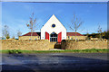
Village Hall and school, Bletchingdon
A new building on a new greenfield site, replacing earlier buildings elsewhere in the village. Most of the school is round the back, but some parts are shared.
Image: © Robin Webster
Taken: 13 Nov 2016
0.03 miles
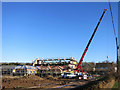
2
Building site, Station Road, Bletchingdon
The far sign has "Children must not play on this site". This invites the defence "But I wasn't playing".
Image: © Robin Webster
Taken: 13 Nov 2016
0.03 miles
3
Building More Bletchingdon
Something fairly serious going up here on the edge of the village.
Image: © Des Blenkinsopp
Taken: 19 Jan 2015
0.04 miles
4
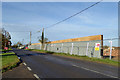
Building site, Bletchington
Just what this will be was not evident, but it was a farm field, with a barn in a small part of it.
Image: © Robin Webster
Taken: 13 Nov 2016
0.04 miles
5
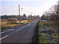
Approaching Bletchingdon
Coming into the village along the B4027 and heading towards Stanton St John
Image: © Bill Johnson
Taken: 13 Dec 2007
0.05 miles
6
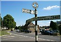
Ton or Don?
The place name here usually has a D in it, as in this sign.
But sometimes it has a T, like at the other end of the village.
Image
Image: © Des Blenkinsopp
Taken: 19 Jan 2015
0.05 miles
7
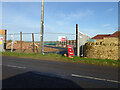
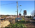
Old Village sign, Bletchington
One of the few remaining old village signs in Oxfordshire, this well preserved signpost is located on the Kirtlington Road junction, Bletchington. In the background is The Black Head public house.
Image: © Kurt C
Taken: 31 Jul 2007
0.06 miles
8
Duchy Field development, Bletchingdon
It appears to have elements of the fictional Camelot.
Image: © David Howard
Taken: 21 Jan 2020
0.07 miles
9
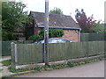
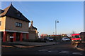
Former Telephone Exchange, Bletchingdon
Situated in Station Road, this former TE was replaced by a larger building nearby sometime during the 1970s, SP5017 refers http://www.geograph.org.uk/photo/2273045. It would now appear to be in use as a back shed.
Image: © David Hillas
Taken: 25 Sep 2010
0.08 miles
