IMAGES TAKEN NEAR TO
Charlton On Otmoor, KIDLINGTON, OX5 2UX
Introduction
This page details the photographs taken nearby to OX5 2UX by members of the Geograph project.
The Geograph project started in 2005 with the aim of publishing, organising and preserving representative images for every square kilometre of Great Britain, Ireland and the Isle of Man.

There are currently over 7.5m images from over14,400 individuals and you can help contribute to the project by visiting https://www.geograph.org.uk
Image Map
Images are licensed for reuse under creativecommons.org/licenses/by-sa/2.0
Notes
- Clicking on the map will re-center to the selected point.
- The higher the marker number, the further away the image location is from the centre of the postcode.
Image Listing (11 Images Found)
Images are licensed for reuse under creativecommons.org/licenses/by-sa/2.0
Image
Details
Distance
1
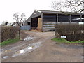
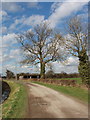
Home Farm, Charlton on Otmoor
View from road junction
Image: © David Hawgood
Taken: 2 Mar 2007
0.03 miles

4
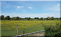
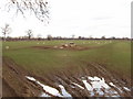
Buttercups at Home Farm
Another picture showing how plant growth shows up the old ridge and furrow patterns which are in the fields all round here. The buttercups prefer the drier soil on the ridges.
For a different view of this process see Image
Image: © Des Blenkinsopp
Taken: 18 May 2020
0.11 miles
6
Sheep and lambs
View from Mansmoor Road.
Image: © David Hawgood
Taken: 2 Mar 2007
0.14 miles
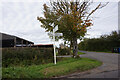
7
Lane to Merton
Lane to Merton passing footpaths to Charlton-on-Otmoor and Weston-on-the-Green
Image: © Shaun Ferguson
Taken: 25 Feb 2009
0.17 miles
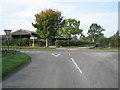
8
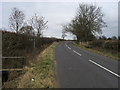
Mansmoor Road
A farm track and bridleway.
Image: © David Hawgood
Taken: 2 Mar 2007
0.20 miles
9
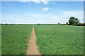
A Very Clear Footpath
No mistaking the way here, but further along it has changed a lot. Older maps show this path as a reasonably direct walk between Charlton on Otmoor and Weston on the Green. But since the railway in between was upgraded from a branch line to main line standards, the old footpath crossing has been closed and a long diversion has been made to a road bridge which adds around 2 kms to the route.
Image: © Des Blenkinsopp
Taken: 18 May 2020
0.22 miles
